Pedestrian View Of Los Angeles

This blog focuses on rail lines in LA country that exist, are under construction or under consideration. The Californian high-speed rail project and southern CA to Vegas project will also be covered. Since most of the relevant developments in the news, rail websites and blogosphere take place on weekdays, this blog will be updated primarily Monday through Friday and occasionally on the weekends. Your comments, criticism and suggestions are encouraged. Miscellaneous stuff will also appear here.

More content as you stroll down on the right side

1. Blog Archive
2.
Blog List and Press Releases
3.
My Blog List
4.
Rail Lines: Existing, Under Construction and Under Consideration
5.
Share It
6.
Search This Blog
7.
Followers
8.
About Me
9.
Feedjit Live Traffic Feed

Friday, July 10, 2009

Google Transit Officially Launches with Metro, Big Blue Bus Coming Soon (Source: LAist)

Link: Google Transit Officially Launches with Metro, Big Blue Bus Coming Soon - LAist
Google Transit Officially Launches with Metro, Big Blue Bus Coming Soon


View Larger Map

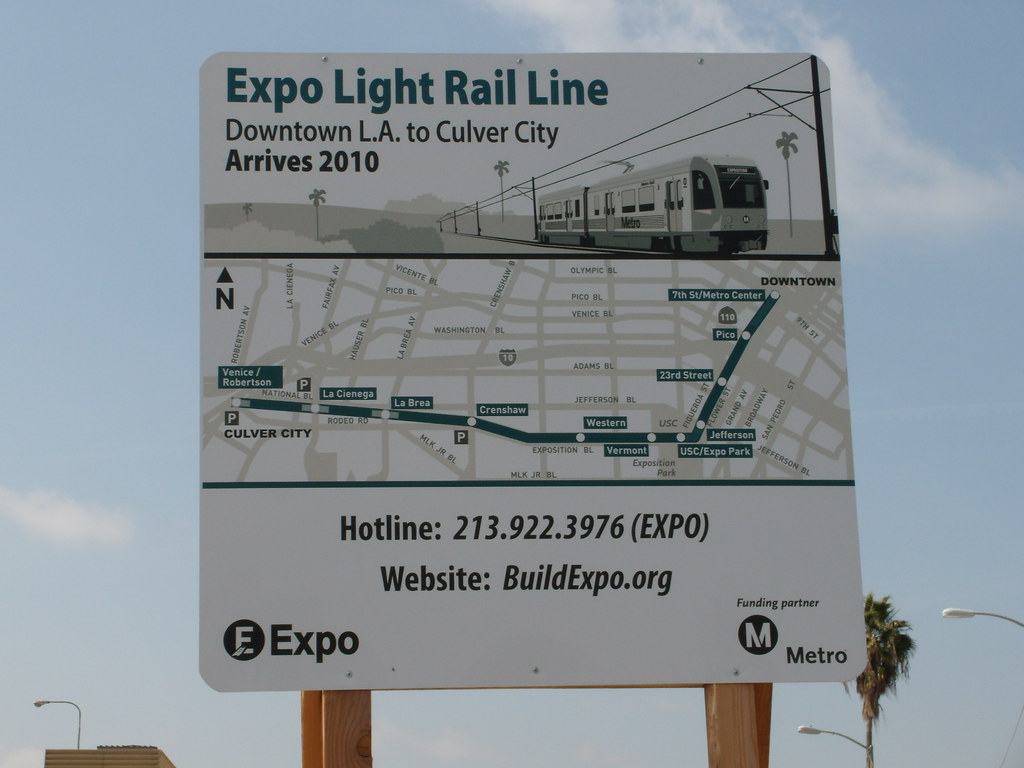
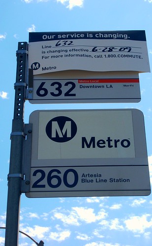
Earlier this week, word got around that Google Transit was up and working in beta mode. Today, it became the real deal. Over 200 bus lines and five lines with more than 2.5 million data points are now on Google Transit, an option found on Google Maps.

"This is a big milestone in Metro history," exclaimed Maya Emsden, the transit agency's Deputy Executive Officer of Creative Services. "We're very excited with our partnership with Google Maps." Perhaps even more excited is the public, many of whom begged Metro to partner with Google.

Google Transit is a free service for Metro and staff expect it to increase ridership, especially during off-peak times, said spokesman Dave Sotero. Now people who plan their driving directions on Google Maps will have an option to look at what's available via public transit.

In an online demonstration this morning, Jessica Wei of Google showed how it was easy to compare drive time to public transit time using the map's historical freeway traffic data. Let's say you're planning to travel over the Cahunega Pass from Universal Studios to Downtown during rush hour on a Friday morning. The traffic pull down offers real time traffic or traffic by day and time. A ride on the red line is around 25 minutes and Google Maps traffic data says the route is up to 40 minutes with traffic. The choice is up to you.

Today's announcement also is good for locals and tourism as Google Transit is compatible in 40 languages, easily used on a mobile phone, works for the visually impaired and can help you find public transit options by searching the business name instead of address.

On Monday, LAist readers found quirks with the system, sometimes being told a bus line that was slower than another. Wei said many of the complaints and data errors will be fixed by Friday, but says any and all suggestions are welcome. Just go to google.com/transitpartners and report issues via the Contact form for feature improvements and issues.

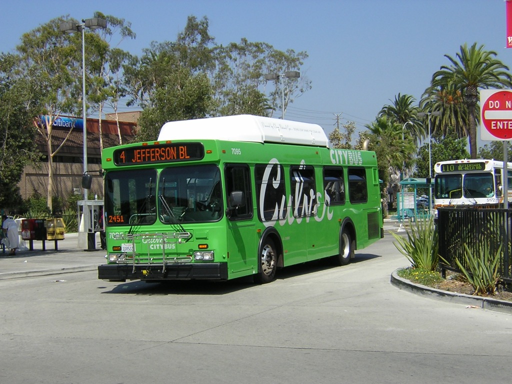
While Metro is the largest transit operator in Los Angeles County, there is a plethora of partner agencies like the city of Los Angeles' DASH system and Santa Clarita Transit. Only a handful--Orange County, Riverside, Metrolink, Burbank and Thousand Oaks--are currently with Google Transit, but Wei says they are talks with many more.

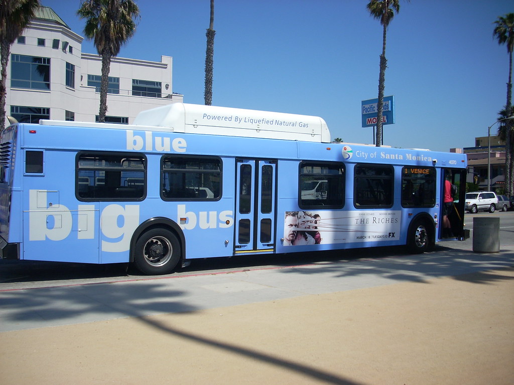
One of those is Santa Monica.

"Big Blue Bus has been working diligently towards bringing our information on to Google Transit for over a year," said spokesperson Linda Gamberg in a comment on Green LA Girl. "We are finally in the home stretch with the vendor who provides our scheduling software, and expect to be part of Google Transit within this calendar year."

As for what's next, much of that will depend on what developers come up with. Last month in preparation for today's launch, Metro released Google Transit data so individuals and companies could make their own applications and mash-ups. On the East Coast, some agencies have an overlay where you can watch the bus in real time arrive at a location. No word on that happening in Los Angeles yet, but it could happen one day.

Metro will continue to promote it's own Trip Planner on its website, which will include all partner agencies, but will also link to Google Transit.

“We have listened to our customers and have provided the Google transit planning resource they have requested,” said Metro CEO Art Leahy in a statement. “As the third largest transportation agency in the United States, it made perfect sense for us to join the Google phenomenon."
user-pic
By Zach Behrens in News on July 9, 2009 1:25 PM


Google Makes it Easier to Get Around LA (Source: NBC Los Angeles)

Link: Google Makes it Easier to Get Around LA | NBC Los Angeles
Google Makes it Easier to Get Around LA

By SCOTT WEBER

Updated 5:16 PM PDT, Thu, Jul 9, 2009


Put away the maps, guys. Google has you covered.


Soon Google will know everything and own the world. Thursday put them one step closer. The search gurus and the Metropolitan Transportation Authority signed a deal Thursday to make it easier for travelers to use the Web to plan Los Angeles-area trips on Metro buses and trains.

Google Maps will provide routes and schedules for the nearly 200 bus lines and five rail lines that Metro operates within the county. The Web site also provides information on the length of each leg of the journey, traffic data for specific times and days, walking directions to bus stations and transit stops, other points of interest on the route, and even street-level photos.

Metro officials said no other online mapping service puts transit data in the context of so much other useful information.

"We have listened to our customers," Metro CEO Art Leahy said. "As the third largest transportation agency in the United States, it made perfect sense for us to join the Google phenomenon."

Tourists are another target of the service. Nearly 4.7 million international visitors came to Los Angeles last year. Metro officials hope the convenience of the the service will encourage more people to park their cars and take public transportation instead. Currently, an average of 1.5 million people board its bus and rail system every weekday.

Google will provide information on Metro services only. For other transit information, visitors can still go to Metro's own Trip Planner at Metro.net.


Copyright City News Service / NBC Los Angeles


Expo Line Transit Service Interface Proposal — Part 3: Metro (Source: MetroRiderLA)

Link: Expo Line Transit Service Interface Proposal — Part 3: Metro | MetroRiderLA
Expo Line Transit Service Interface Proposal — Part 3: Metro
Contributed by Wad on July 10th, 2009 at 3:00 am

Expo Line construction sign

The Expo Line is coming, but it may be in 2011. The bus service changes below are suggested to help both bus and rail riders.
Photo by Alan Weeks and uploaded by Metro Library and Archive on Flickr; used with a Creative Commons license

MetroReaders, we have arrived at the third and final installment of the Expo Line Transit Service interface proposals. Thank you to all of those who have read and participated in the discussions of the other two proposals for Culver CityBus and Big Blue Bus. Metro, as the operator of the Expo Line and the largest bus system in the county, has a lot to go ahead. The line’s opening date may be some time in 2011, with Phase 2 to Santa Monica another four years after that.

Phase 2 is at the centerpiece for the initial segment of the Expo Line, as you will see below. One of the most important suggestions of the bus lines proposed is … wait for it … a Phase 2 Gold Line emulator.

You are probably reading this and rolling your eyes. One criticism I am expecting is: “You want this to end up like Line 632’s rise and fall?” That is the last thing I want. Here’s the difference. The Expo Emulator would be planned along with regular service, not put together on the fly. Second, it is going to last for at least four years, so it has some time to build a ridership base. Third, it would emulate the path of Expo Phase II but follow a slightly different path. Fourth, the Expo Emulator is a pre-emptive solution to what is bound to be a major Expo Line problem: What to do about all those passengers transferring from Expo and heading west, particularly on Line 33/333 — on which ridership is extremely heavy now, and unable to handle a swarm of passengers hoping to transfer when the rail line opens.

The other proposal also suggests the turnover of some Metro services to Santa Monica or Culver City. These are only requests to see if the munis are willing or capable of taking on additional service. Both the blue and green buses can operate services about 10 percent cheaper than Metro, according to figures on the National Transit Database. This is especially helpful for low-performing, high-cost lines. Some of the Metro lines proposed for municipal turnover include 4, 30/31, 35, 38 and 534.

There are also some service improvements suggested for the Westside that do not tie in directly with the Expo Line, but would be helpful to plan for them concurrently. I have also reposted some of the route changes that would affect the Expo Line TSIP routes mentioned before in the Eastside Gold Line TSIP. I can’t cut and paste routes from one map to the other, but I can add the original route proposals here as a refresher.

Compare the existing Metro system map with the changes proposed on the Google Map. As a reminder, these proposals are not official by any agency and are not endorsed by them. Also, please send in any comments you may have by the end of the month by posting them on this board or including your name in an e-mail. All suggestions will be forwarded to the respective agencies’ planners.

The table of changes and rationales follows the jump.

Expo Emulator

Rationale: This special bus line would be a temporary gap until Expo Phase II opens. It would emulate the future Expo Stations, but along Pico Bl. If Metro has the resources and the police permission, it should install temporary ticket vending machines at the stops to expedite boardings. Although it is a bus, Expo Emulator would help “prime” the ridership for when light rail service is extended, and perhaps add riders who originate trips in the Westside to board the Expo Line.

The other reason is to stem an expected operational bottleneck caused by the end-of-the-line transfer. Line 33 would bear the brunt of heavy transfer activity. If riders do not shift rides from 33 to Expo, there would be no room for transfers. Or, riders do shift their trips, but Culver Junction becomes the site of a massive rider log-jam that may force passengers to wait long periods before a local or Rapid 733 arrives. The Expo Emulator would serve to stem this problem by transporting riders to Santa Monica, making only stops close to proposed Phase II stations.

The Expo Emulator would primarily run along Pico Bl. While Venice Bl. would have Line 733 Rapid service, ridership would be at existing levels or much higher, not allowing it to bear the load. Pico is the biggest street with frequent service and important destinations including Westside Pavilion, Santa Monica College and Santa Monica High School.

Route: Culver Junction Expo Line Station, Washington Bl., Venice Bl., National Bl., Overland Av., National Bl., Westwood Bl., Pico Bl., 4th St., Colorado Av., 2nd St., Santa Monica Bl., 4th St. & Santa Monica Bl. and 4th St.

Expo Emulator makes only the following stops:
Culver Junction Expo Line Station, National Bl. & Palms Bl. (Palms), Overland Av. & National Bl., Westwood Bl. & Pico Bl. (Westside Pavilion), Pico Bl. & Sepulveda Bl., Pico Bl. & Bundy Dr., Pico Bl. & 18th St. (Santa Monica College), Pico Bl. & Lincoln Bl. (Santa Monica High School), 4th St. & Santa Monica Bl.
Line 105
Line 305
Line 550

Rationale: Lines 305 and 550 run similar services, yet they have never been productive lines. A restructured Line 105 would provide service from the Vernon Blue Line station to Century City. It would lose the routing west of the Baldwin Hills Crenshaw Plaza and continue via Crenshaw Bl. to Pico Bl., then via San Vicente Bl., Burton Way and Santa Monica Bl. to Century City. It would replace Line 16 service west of Cedars-Sinai.

Service along Martin Luther King Bl. would be replaced by Line 40 (see Eastside Gold Line Transit Service Interface Proposal). La Cienega Bl. service would be replaced by a restructured Line 217.
Line 108
Line 358

Rationale: Line 108’s Marina del Rey segment suffers from unreliable service, due to being an hourly tail on a busy trunk service. Line 108 would now terminate at Westfield Shoppingtown Fox Hills. Marina del Rey service would be provided by Culver CityBus Line 7 (see Culver City proposal). Line 108 would be extended east on Slauson to Rosemead Bl.

Line 358’s service change, shown in the Eastside Gold Line Transit Service Interface Proposal, would take the route north on Atlantic Bl. from Slauson Av. to connect with the Gold Line at the Atlantic/Pomona Station.

Route (Line 108 only): Rosemead Bl., Bermudez St., Bequette Av., Slauson Av. and Westfield Shoppingtown Fox Hills.
Line 110

Rationale: Due to a change proposed for Culver CityBus Line 3 (see Culver CityBus proposals), Line 110 would pick up the Fox Hills-adjacent routing on its route. The line would be shortened to terminate at Westfield Shoppingtown Fox Hills. Its eastern terminal would also be extended to Slauson Av. and Telegraph Rd. Also, a route deviation would be added to serve the Slauson Av. Harbor Transitway Station.

Route: Westfield Shoppingtown Fox Hills, Slauson Av., Buckingham Pkwy., Hannum Av., Bristol Pkwy., Centinela Av., Hyde Park Bl., Van Ness Av., 62nd St., Western Av., Gage Av., Figueroa St., Slauson Av., Slauson Harbor Transitway Station, Broadway, Gage Av., Compton Av., Florence Av., Holmes Av., Gage Av., Slauson Av., Telegraph Rd., Bluff Rd. and Slauson Av.
Line 212

Rationale: With the restructuring of Line 40, Line 212 becomes the crosstown service from Hollywood to Redondo Beach via La Brea Av. and Hawthorne Bl. See the Eastside Gold Line Transit Service Interface Proposal.

Route: Hollywood Bl., Hollywood/Vine Red Line station, Argyle Av., Selma Av., Vine St., Hollywood Bl., La Brea Av., Overhill Dr., Slauson Av., La Brea Av., Inglewood Transit Center, La Brea Av., Hawthorne Bl., Hawthorne/I-105 Green Line Station, Hawthorne Bl., 177th St, Kingsdale Av., South Bay Galleria Transit Center, Artesia Bl., and Hawthorne Bl.
Line 217

Rationale: With the availability of Line 780 and the return of Metro Line 1, the existing Line 217 would no longer need to continue to Hollywood. The restructured Line 217 would be a bidirectional loop along Fairfax Av. and La Cienega Bl. This would help balance similar north-south lines with headways close to the existing Line 217.

Route: Fairfax/La Cienega Expo Line station, Fairfax Av., Sunset Bl., La Cienega Bl. and Fairfax/La Cienega Expo Line station.
Line 220

Rationale: Despite low ridership and threats by Metro to eliminate this service, Expo Line may help restore relevancy to this moribund route. Line 220, like Line 217, would become a bidirectional loop along Robertson Bl. and Beverly Dr., which would no longer be served by Line 14.

Each loop would run hourly, but the shared route on Robertson between Pico Bl. and the Expo Line would replace service that is lost by Big Blue Bus Line 12 now terminating at Culver Junction. The shared portion of service would run every 30 minutes.

Route: Venice Bl., National Bl., Washington/National Expo Line Station, Washington Bl., Robertson Bl., Santa Monica Bl., Canon Dr., Wilshire Bl., Beverly Dr., Pico Bl., Robertson Bl., Venice Bl., National Bl. and Washington/National Expo Line Station.
Line 312

Rationale: To offer a more productive route, a deviation would be added to Leimert Park to connect with other bus services at Crenshaw Bl. and Martin Luther King Jr. Bl. The route would also be shortened to Inglewood. Also, when the development at Hollywood Bl. & Vine St. is completed, revert Line 312 to peak-hour service, but continue offering bidirectional service.

Route: Hollywood Bl., Hollywood/Vine Red Line station, Argyle Av., Selma Av., Vine St., Hollywood Bl., La Brea Av., La Brea Expo Line station, La Brea Av., Rodeo Rd., Martin Luther King Jr. Bl., Crenshaw Bl., Florence Av., Market St., Manchester Av. La Brea Av. and Florence Av.
NEW Line 356

Rationale: Normandie Av.’s Line 206 has the ridership and transfer activity, like its nearby Vermont Av. and Western Av., services to support limited-stop buses. Line 356 would run bidirectional peak-hour limited-stop service and connect with the Expo Line at Vermont.

Route: Sunset Bl., Virgil Av., Fountain Av., Vermont Av., Vermont/Sunset Red Line station, Sunset Bl., Normandie Av., Wilshire/Normandie Purple Line Station., Normandie Av., Irolo St., Normandie Av., Jefferson Bl., Vermont Av., Vermont Expo Line station, Vermont Av., Martin Luther King Jr. Bl., Normandie Av., Imperial Hwy., Vermont Av., Vermont/I-105 Green Line Station, 120th St., and Normandie Av.
NEW Line 539X

Rationale: Line 439 would no longer be needed once Expo Line is operational, but an attempt should be made to serve its busiest transfer points. The prototype name is 539X, and would use blue express buses to connect Culver Junction with LAX and the Aviation/I-105 Green Line station. The bus would use mostly surface streets, but it would have only major destination stops along the line. It would operate hourly, 7-day service, just as 439 does now.

Line 439 would be replaced by new Culver CityBus Line 8 through Baldwin Hills. The list of exact stops is in the pop-up menu when the route is clicked.

A major issue that’s sure to arise is Culver City’s possible objection to a service operating mostly within its territory. One possibility would be to offer Culver CityBus operation of the line with Metro paying for it, but withdrawing funds if the line proves to be unproductive.

Also, the schedule would need to be adjusted to avoid West Los Angeles College service when it’s not in session.

Route: Culver Junction Expo Line Station, Washington Bl., Culver Bl., Duquesne Av., Jefferson Bl., Overland Av., Freshman Dr., A St., B St., F St., Freshman Dr., Overland Av., Playa St., Sepulveda Bl., Fox Hills Mall, Sepulveda Bl., Howard Hughes Pkwy., I-405, Century Bl., Vicksburg Av., 96th St., LAX City Bus Center, 96th St., Vicksburg Av., Century Bl., Aviation St. and Aviation/I-105 Green Line Station.
Line 780

Rationale: The route stays the same, but its west terminal would now be Fairfax/La Cienega Expo Line station, but 7-day service would be added on Fairfax Av. to compensate for Line 217 becoming a Fairfax Av.-La Cienega Bl. bidirectional loop.
The following is a list of suggestion first proposed in the Eastside Gold Line Transit Service Interface Proposal. They are refreshed here.
NEW-Line 1

Rationale: This line would save transfers by creating a crosstown route between East Los Angeles and Hollywood through Downtown L.A., Echo Park and Silver Lake. It would restore the Line 1/217 configuration seen until 1999. Line 68 would be canceled and replaced by Line 1, and its interlined Line 84 would become a stand-alone route. This route change consists of two phases.

Phase 1 (Eastside Gold Line opening): Line 1 operates between Atlantic Gold Line Station and Vermont/Sunset Red Line station. Line 1 lays over then continues as Line 217 on its present route.

Phase 2 (Expo Line opening): Line 217 becomes a bidirectional loop on Fairfax Avenue, no longer running to Hollywood. Service to Hollywood would be provided on existing Rapid Line 780, which would get 7-day service on Fairfax Av. Replacement service on Hollywood Bl. would now be provided by Line 1, which would be extended to Santa Monica Bl. and San Vicente Bl.

Route (Phase 1): Atlantic Gold Line station, Atlantic Bl., Cesar Chavez Av., Sunset Bl., Hollywood Bl., Vermont Av., Sunset Bl., Virgil Av., Fountain Av.
Line 4

Rationale: The only change would be to shorten the route from Hill St. & Venice Bl. to Union Station. In the long-term, Metro should consider turning over operation of local Line 4 to Santa Monica’s Big Blue Bus, which would operate Line 1 from Santa Monica to the Vermont/Sunset Red Line station. Metro would retain Rapid Line 704 between Union Station and Santa Monica.

Route: Patsaouras Transit Plaza, Vignes St., Sunset Bl., Sanborn Av., Santa Monica Bl. to Sepulveda Bl. or Santa Monica. Under theoretical turnover to Big Blue Bus, route would begin at Vermont/Sunset Red Line Station, then Sunset Bl., Sanborn Av., Santa Monica Boulevard to Santa Monica. Local service on Sunset would be provided by Metro Line 1 and Line 2, and Rapid service on Line 704.
Line 14

Rationale: Changes come to Line 14 in two phases. The first phase is to eliminate the interline with Line 37 to improve service. Line 14 would originate at Union Station.

The second phase of changes is implemented with the opening of the Expo Line. The Beverly Dr. portion would be split off and attached to Line 220, which becomes a bidirectional loop along Robertson Bl. and Beverly Dr.

Route: Union Station, Vignes St., Cesar Chavez Av., Alameda St., 1st St., Beverly Bl, Santa Monica Bl., Civic Center Dr., Little Santa Monica Bl., Beverly Dr. In Phase 2, when Expo Line opens, Line 14 terminates in Beverly Hills and Line 220 takes over Beverly Dr. route.
Line 16
Line 316

Rationale: The primary goal is to shorten and hopefully eliminate Line 30 and 31, while still providing an east-west crosstown route with identical levels of service. Line 30/31 would not operate east of downtown L.A., and the plan would be to work out an arrangement with Santa Monica’s Big Blue Bus to operate Line 7 between downtown L.A. and Santa Monica, and Metro providing Rapid Line 707, the merger of Rapid Line 730 and Rapid 7.

The replacement crosstown route is Line 16, which would run between East Los Angeles College and Cedars-Sinai or Century City via 1st and 3rd streets in Phase 1. Line 316 would only operate west of downtown L.A., as to not duplicate limited-stop service by the Gold Line. In Phase 2, when the Expo Line opens, Line 16/316 is rerouted to terminate in West Hollywood. Service between Cedars-Sinai and Century City is replaced by rerouted Line 105.

Route: (Phase 1) East L.A. College, Collegian Dr., Floral Dr., Atlantic Bl., 1st St., Beaudry Av., 3rd St., Robertson Bl., Burton Wy., Santa Monica Bl., Century City.
(Phase 2) East L.A. College, Collegian Dr., Floral Dr., Atlantic Bl., 1st St., Beaudry Av., 3rd St., Robertson Bl., Santa Monica Bl., San Vicente Bl. and Melrose Av.
Line 30
Line 31
Rapid Line 730
Santa Monica’s Big Blue Bus Line 7
Santa Monica’s Big Blue Bus Rapid 7

Rationale: The phases of these lines along Pico would be planned for the opening of the Expo Line. Metro should consider splitting service with Santa Monica’s Big Blue Bus and operating a single service along Pico.

Service along 1st St. would be replaced by Line 16.
Line 35

Rationale: The immediate proposal would be to restore bus service on Alameda St. and provide another Westside connection to the Gold Line. Also, Metro should consider turning over operation of Line 35 to Culver CityBus, which would merge it into Line 1 for a West Washington Bl., service between Venice and Downtown L.A.

Route: Union Station, Vignes St., Alameda St., Washington Bl., Fairfax Av. and West L.A. Transit Center.
Line 37
Line 55

Rationale: With Line 14 no longer paired to it, Line 37 could instead be paired with Line 55, which partly runs along Adams Bl. This change can be postponed until the opening of the Expo Line.

Route: West L.A. Transit Center, La Cienega Bl., Adams Bl., Hooper Av., 41st St., Compton Av., Firestone Bl., Maie Av., 89th St., Compton Av., 92nd Av., Compton Av., 120th St., Willobrook Av., and Rosa Parks Blue and Green Line Station.
Line 38

Rationale: There are two phases to Line 38 changes.

Phase 1 involves Line 38 assuming the eastern portion of Line 102. Phase 2 has significant changes with interlines or possible turnover to Culver CityBus.

Route: West L.A. Transit Center, La Cienega Bl., Jefferson Bl., Central Av., 41st St., Hooper Av., Gage Av., Central Av., Florence Av., Seville Av., Liberty Bl., Long Beach Bl., Palm Pl.
Line 40
Rapid Line 740

Rationale: The route would be shortened to focus on local service while Line 740 continues along its present route. The rerouted Line 40 will no longer run south of Crenshaw Bl. & Martin Luther King Jr. Bl. Instead, it will run between Mid City and Lincoln Heights at present service levels.

Line 212 would replace Line 40 service along Hawthorne Bl. at present service levels, becoming a La Brea Av.-Hawthorne Bl. crosstown route.

Route: Exposition Bl., Rimpau Bl., Jefferson Bl., La Brea Av., Rodeo Rd., Martin Luther King Jr. Bl., Broadway, 1st St., Mission Rd., Marengo St., Cornwell St., Zonal Av., Mission Rd., Daly St., Ave. 26, Figueroa St., Cypress Av., and Idell Av.
Line 42
Line 102

Rationale: This route change may be postponed until the opening of the Expo Line, or implemented to serve the Eastside Gold Line but terminating at Union Station. Line 42 would become its own line instead of a Line 40 branch. It would take over the Exposition Bl. routing of Line 102, which would now be canceled, then resume its present route south of Leimert Park. Line 42 would also be extended to serve the Aviation/I-105 Green Line station. In Phase 2, it would be interlined with Line 44.

Route: (Phase 1) Union Station, Vignes St., Cesar Chavez Av., Alameda St., 1st St., Spring St. (Main St. northbound), Jefferson Bl., Figueroa St., Exposition Bl., Rodeo Rd., Crenshaw Bl., Coliseum St, Martin Luther King Jr. Bl., Crenshaw Bl., Stocker St., Overhill Av., Slauson Av., La Tijera Bl., Sepulveda Bl., 96th St., LAX City Bus Center, Airport Bl., Century Bl., Aviation Bl., and Aviation/I-105 Green Line station.
(Phase 2): Main St., 23rd St., Flower St., Washington Bl., Main St., then via Phase 1 routing.
NEW Rapid Line 705
Rapid Line 751

Rationale: Rapid Line 751 would merge into Line 705, providing a long but potentially productive service through the Eastside, South L.A., and West Hollywood. Line 705 would now be terminated at County/USC Medical Center.

When the Expo Line opens, line would be rerouted to serve the Culver Junction station.

Route: Marengo St., Mission Rd., Zonal Av., County/USC Medical Center, Cornwell St., Marengo St., Soto St., Soto Gold Line Station, Leonis Bl., Pacific Bl., Vernon Av., Crenshaw Bl., Martin Luther King Jr. Bl., Rodeo Rd., La Cienega Bl., Melrose Av., San Vicente Bl., Santa Monica Bl. and La Cienega Bl.


Call to shift car plants to bullet trains (Source: San Francisco Business Times)

Link: Call to shift car plants to bullet trains - San Francisco Business Times:
Thursday, July 2, 2009
Call to shift car plants to bullet trains
San Francisco Business Times

In one of his last acts as chairman of the state’s high speed rail authority, Quentin Kopp is proposing that shuttered auto plants be converted into bullet train factories.

Kopp, a Bay Area judge who will remain a member of the state-chartered authority, introduced a resolution Thursday encouraging U.S. and California authorities to consider ways to make the switch.

Kopp said that as auto plants in Michigan, Tennessee, Wisconsin, Indiana, Ohio and California are shuttered by auto giants like General Motors Corp., the country has the opportunity to promote jobs through the construction of bullet trains.

Just this week northern California appeared to be on the verge of losing its only auto plant. GM said it would pull out of a joint venture with Toyota Corp. in Fremont because the two companies could not agree on what model to build there.

Kopp, who has been chairman of the high-speed rail authority for three years, was one of the most vocal proponents of a bullet train in California. The high speed rail authority proposes building a train that links the Bay Area with southern California.

Federal transportation officials said California is one of two states that are leading candidates to secure federal money for high-speed passenger-rail service. “California and Florida are way ahead of the curve,” U.S. Transportation Secretary Ray LaHood said last May.

The U.S. Department of Transportation in coming months will start awarding $8 billion under the economic-stimulus program to states with the most attractive plans for building bullet trains or upgrading passenger rail service.

The state has almost $10 billion in money approved by voters last year and a designated route. The state will need many billions of dollars more and expects to tap private investors as well.

Curt Pringle, the mayor of Anaheim, is expected to replace Kopp as chairman of the high-speed rail authority.

eyoung@bizjournals.com


Reid uses corridor designation to show backing for private project (Source: Las Vegas Sun)

Link: A boost for DesertXpress - Las Vegas Sun
A boost for DesertXpress:
Reid uses corridor designation to show backing for private project


Leila Navidi

Senator Harry Reid, with Transportation Secretary Ray LaHood, holds a press conference about a proposed high-speed train that would go from Las Vegas to Southern California in downtown Las Vegas Thursday, July 2, 2009.

By Lisa Mascaro & Stephanie Tavares

Friday, July 3, 2009 | 2 a.m.
High-speed train press conference


* U.S. Transportation Secretary Ray LaHood speaks at a press conference on Thursday, July 2, 2009.


Chris Morris

Nowhere on the official documents from Thursday’s announcement of a new high-speed rail corridor between Las Vegas and Los Angeles is the proposed DesertXpress featured as the preferred project.

But make no mistake: DesertXpress is the chosen one, at least for now.

Senate Majority Leader Harry Reid backs the private venture, and he let it be known that the privately backed train to Victorville, Calif., not the once-hoped-for magnetic levitation train to Anaheim, was the one for which the Transportation Department’s new corridor is intended.

The publicly run $12 billion maglev proposal has worn out its welcome after 30 years in the planning stages, Reid said. He reiterated that he is ready to put his efforts into the newer DesertXpress.

“I’m not going to put any more of my (time) into maglev,” Reid said. “It’s time for action in this corridor. We’re past the planning stage; we’ve got to move on and start the construction.”

Reid predicted that the $5 billion Desert-

Xpress, backed by his political supporter Sig Rogich, a Republican leader in Nevada, would be up and running by 2012. Ground would be broken early next year, and Reid said it would be built with “40 to 50 percent” private financing, and the rest government loans, if needed.

The announcement Thursday came with a large map showing the DesertXpress route to Victorville, the high-desert outpost 85 miles north of Los Angeles, and its planned spur to Palmdale to connect with California’s planned north-south line connecting San Francisco, Los Angeles and Orange County.

But the Transportation Department made it clear later in the day that it did not supply that map. Also, Transportation Secretary Ray LaHood declined to weigh in on the fierce competition between the two Las Vegas trains.

“We believe that the development of regional high-speed passenger rail systems will create jobs, spur economic development and provide positive environmental benefits for all Americans,” LaHood said in a statement.

A Transportation spokeswoman later explained that the department did not choose one train over the other. “We didn’t pick a route,” she said. “We know there are obviously two competing proposals. The states decide.”

Technically, the Las Vegas route is an extension of the department’s existing California corridor, an offshoot of that state’s $45 billion line, which will be financed in part by an $11 billion bond passed by voters last fall.

Establishing a corridor will open the door to allow the Las Vegas project to compete for $8 billion in federal stimulus money passed by Congress this year, as well as other federal aid.

However, DesertXpress does not immediately qualify for that money because it is not a state-sponsored agency, which is required under federal guidelines. No private companies can independently qualify.

DesertXpress has insisted it has no interest in tapping the stimulus money, but said it may want low-interest government loans. The company has said it intends to privately finance 30 percent of the cost, but would borrow the rest — about $3.5 billion.

The Transportation Department runs a loan program that can fund 100 percent of the project, payable in 35 years.

Experts say there are virtually no privately run rail lines in operation anywhere in the world because they cannot be built without public money, and cannot turn a profit. The private monorail system in Las Vegas may soon seek public aid.

DesertXpress issued a statement saying it was “thrilled” with the day’s announcement. The company has poured $25 million into planning documents.

“The solid support expressed for our privately funded DesertXpress project today, as part of a great solution to

I-15 congestion and as a lifeline to Nevada’s tourism industry, is significant,” DesertXpress President Tom Stone said.

The publicly run maglev proposal will continue to press on, its backers said.

“We intend to move ahead,” said Neil Cummings, president of American Magline Group, the private consortium hired by the California Nevada Super Speed Train Commission to build the maglev train.

He understood, however, the message at the conference.

“Certainly, there was no mention of the maglev system,” he said.


Thursday, July 9, 2009

LACMTA installs Najarian as chairman, nears light-rail extension opening (Source: progressive railroading.com) The Gold Line Eastside Extension's opening date is still up in the air.

Link: LACMTA installs Najarian as chairman, nears light-rail extension opening
LACMTA installs Najarian as chairman, nears light-rail extension opening

Last week, the Los Angeles County Metropolitan Transportation Authority’s (LACMTA) board elected Glendale City Councilman Ara Najarian as chairman to succeed Los Angeles Mayor Antonio Villaraigosa, whose term expired.

A member of the board governing LACMTA’s Metrolink regional rail system, Najarian was elected to Glendale’s city council in 2005 and later served as mayor from 2007 to 2008. He currently chairs the Glendale Housing Authority and previously chaired the Glendale Redevelopment Agency.

Meanwhile, U.S. Transportation Secretary Ray LaHood and several congressmen toured the Metro Gold Line Eastside Extension on July 3. Nearing completion, the six-mile light-rail extension will connect downtown L.A.’s Union Station with Little Tokyo, the Arts District, Boyle Heights and East L.A. The extension’s opening date will be announced soon after LACMTA completes additional testing, the agency said.


USC professor appointed to direct high-speed train project (Source: ContraCostaTimes.com)

Link: USC professor appointed to direct high-speed train project - ContraCostaTimes.com
USC professor appointed to direct high-speed train project
From news services
Posted: 07/07/2009 04:32:59 PM PDT
Updated: 07/07/2009 04:33:21 PM PDT

LOS ANGELES - A USC professor and urban planner was appointed today to spearhead the development of a maglev train system for Southern California.

Cerritos Mayor Bruce Barrows, who heads the Orangeline Development Authority, chose Michael Kodama as executive director of the project.

Planners envision an elevated, 110-mile-long train line between Irvine and Palmdale. The estimated cost of the overall project is in the $12 billion range.

Barrows called Kodama "the perfect choice for this position," noting his extensive knowledge of Los Angeles and Orange County transportation issues.

Kodama's 20 years of urban planning experience includes the development of freeways, and bus and rail lines.

The UCLA graduate teaches transportation planning at USC and is the president of his own transportation planning firm.

The maglev train would travel as fast as 240 mph and have a passenger capacity on par with the that of an eight-lane freeway, according to the Orangeline Web site.

The train would be able to carry passengers and freight, including container cargo coming off ships, on a route that follows Interstate 5, the Antelope Valley (14) Freeway and parts of the old Pacific Electric line


Site of Original Fatburger Stand in South LA Saved By CRA Deal (Source: LAist)

Link: Site of Original Fatburger Stand in South LA Saved By CRA Deal - LAist
Site of Original Fatburger Stand in South LA Saved By CRA Deal


CurbedLA shares this good-news bit for preservationists and fans of Fatburger, and report that the original 1952 South LA stand where the popular fast food franchise began has been purchased by the CRA and will be preserved and made a part of the new development on the property. According to family rep Frank Evanisko," The actual shack still on the property cannot be torn down but must be rehabbed and incorporated into any new development." The site is destined to be for low income housing; public records indicate "the proposed project will be a 66-unit moderate income housing condominium consisting of 61 residential condominiums and five Live/Work units at 3001-3023 S. Western Avenue." Fatburger was founded by "female African American entrepreneur Lovie Yancey." Yancey died at age 96 in February 2008.

By Lindsay William-Ross in News on July 8, 2009 11:59 AM


LA council orders LAX to study Green Line extension (Source: Daily Breeze)

Link: LA council orders LAX to study Green Line extension - The Daily Breeze
LA council orders LAX to study Green Line extension

By Art Marroquin Staff Writer

Posted: 07/08/2009 07:15:42 PM PDT

The Metro Green Line might finally wind its way down to the terminals at Los Angeles International Airport, thanks to the recent purchase of an adjacent 20-acre parking lot that's ripe for use.

The Los Angeles City Council's Trade, Commerce and Tourism Committee on Wednesday directed airport officials to spend the next six months studying whether it's possible to bring the light rail line directly to LAX by building a stop on the site of the Park 'N Ride at Park One lot, located just east of Terminal One.

The Board of Airport Commissioners agreed last month to buy the parking lot for $126.5 million. The full City Council is expected to sign off on the expenditure by Friday.

"It's a no-brainer that every major airport has a rail line going into it," said Los Angeles City Councilman Bill Rosendahl, whose district includes LAX.

The Green Line's estimated $200 million, two-mile extension would likely be funded by Measure R. Los Angeles County voters approved the half-cent county sales tax measure, which went into effect last week and is expected to generate $40 billion for local transportation projects over the next 30 years.

As part of their research, airport officials will dust off and update a report completed more than a decade ago, examining whether to bring the Green Line to LAX.

"We really want this to be the premier study to say yes, this is feasible and here's how it's going to happen," said Councilwoman Janice
Advertisement
Quantcast
Hahn, who chairs the council committee that oversees LAX.

"If we don't make it accessible, people won't use it," Hahn said. "It's time to right that wrong for the public."

The Green Line, running 20 miles from Norwalk to Redondo Beach, opened in 1995 at a cost of $700 million.

For now, the Green Line's stop at Aviation Boulevard drops passengers two miles away from LAX, forcing travelers to board a bus to complete a trip to the airport.

The rail line's missing link should connect "deep into the heart of the airport," Councilman Tom LaBonge said.

The Los Angeles County Metropolitan Transportation Authority's current plan calls for extending the Green Line to nearby Manchester Square, allowing travelers to board a proposed people mover to gain access to airport terminals.

The MTA had initially called for extending the Green Line to LAX by 2015, but officials announced last year that the project won't likely be completed until 2018 at the earliest.

But MTA officials on Wednesday said they would welcome input from airport and city officials who want to use the airport-adjacent parking lot as a new Green Line stop.

"We're working with the airport in creating a better link to the terminals, but this is a new proposal to us," said Roderick Diaz of the MTA's South Bay planning department.

"We'd have to examine various possibilities to bring the line to the terminals," Diaz said. "But this is an interesting alternative to pursue."

Airport Commission President Alan Rothenberg said the Park One property will continue to operate as a parking lot as officials study all potential uses, including a new consolidated car rental office.

"You have a privately owned piece of property within the footprint of LAX and it's a shame we didn't acquire it the last time it was on the market," Rothenberg said. "It's clear that it should be part of LAX."

art.marroquin@dailybreeze.com


Wednesday, July 8, 2009

Is the State Legislature Going to Screw Up HSR? (Source: California High Speed Rail Blog)

Link: California High Speed Rail Blog: Is the State Legislature Going to Screw Up HSR?
Tuesday, July 7, 2009

Is the State Legislature Going to Screw Up HSR?

The California State Legislature isn't exactly the most popular group of people these days. As the state budget crisis worsens - and as California's bond rating takes another hit - Californians are losing what little patience they had for their legislators, who remain unable to produce a budget solution. It's not for lack of trying, as the 2/3rds rule and Republican obstinacy has produced the ongoing delays and deficits. But it reflects poorly on the legislators, who are facing some of the lowest approval ratings ever.

It doesn't help matters when the Legislature proposes something that is manifestly stupid, wasteful, and unnecessary. And that is what has happened regarding high speed rail on the peninsula, where the legislature has caved to Peninsula NIMBYs at the possible cost of $1 billion in stimulus funds:

An obscure sentence inserted deep in a massive state budget bill could delay construction of the proposed high-speed rail route from San Jose to San Francisco, potentially costing the region more than $1 billion in federal stimulus money, high-speed rail planners said Monday.

The language requires that as a condition of getting $139 million next year from the state budget to hire staff and engineering firms, the state High Speed Rail Authority must study "alternative alignments" to the route along the Caltrain tracks, approved by the authority last July.

Though the bill has passed both chambers of the state Legislature, its fate is uncertain because it remains part of the bigger state budget imbroglio.


This is ridiculous. The CHSRA already studied the Peninsula corridor, already studied the Altamont alignment, and already concluded that the Caltrain corridor is the best solution. They spent 11 years on these studies. Neither the Legislature nor the Peninsula NIMBYs have any place calling for another study just because they didn't like the outcome of the first one.

This is especially troubling given the financial implications of the Legislature's meddling:

On Monday, Rod Diridon, a former Santa Clara County supervisor who sits on the high-speed rail board, said that restudying the route could jeopardize federal stimulus money that requires eligible projects have construction started by September 2012.

"If it were to stay in, only our corridor in the whole state would be penalized, and all the federal stimulus money would go to Southern California," Diridon said.

The San Jose-to-San Francisco route will be seeking $1.3 billion in stimulus money, Diridon said. Two other proposed high-speed-rail routes near Los Angeles also will be seeking similar amounts.


The Peninsula NIMBYs would be perfectly happy with this outcome - their goal is to kill the HSR project in their own backyard, and have shown no regard for fiscal responsibility (such as their proposal of an extremely costly tunnel without offering any method of paying for it).

But it would cost the state as much as $1 billion in HSR stimulus, which translates into thousands of jobs and a not insignificant boost to the local economy on the Peninsula, which in turn means rising tax receipts in Sacramento. I'm not surprised at the Peninsula NIMBYs for not caring about any of this. I am surprised at the Legislature for being incredibly reckless by approving this proposal.

Sen. Joe Simitian, who represents Palo Alto, understands as much, as he denied responsibility for this moronic provision:

Adding to the drama Monday was that neither Diridon nor any other member of the high-speed rail board said they knew who wrote the provision requiring the extra study.

"We're all mystified. The whole board was caught by surprise how the language got in the bill," Diridon said.

State Sen. Joe Simitian, D-Palo Alto — whose constituents are most upset by the route — said he's not the author.

"That's not my language. I didn't have anything to do with it," he said.

Political skulduggery may not be to blame. In the rush to finish the budget, legislative staff members crafted the new requirement based on what Peninsula residents who testified at hearings and senators seemed to want, said Brian Annis, transportation budget consultant on the state Senate budget committee.

"We were incorporating many different comments and issues that staff and legislators were involved in," Annis said. "As far as the specific language, we drafted something we thought was workable."


So the problem seems to be in the Senate Budget Committee. There are a LOT of Senators on that committee - including one familiar name:

Senator Alan Lowenthal.

Now granted, we don't know whether he was responsible for this provision. But it would not surprise me if he were. Senator Lowenthal has been working for the last year to gut the HSR project. My assessment has always been that he wants to turn the HSR project into a vehicle to deliver funds to commuter rail projects in Southern California, and that he has no commitment to the statewide project, and certainly not to the route voters approved in Prop 1A at the November 2008 election.

Was he behind the provision in question that would undermine the HSR project AND cost California $1 billion in HSR stimulus? We don't know, but someone in the Legislature was, and they're currently trying to keep quiet. These things don't just wind up in the legislation by accident. California deserves to know who in the State Senate believes that a few NIMBYs should have the power to upend 11 years of studies and cost the state $1 billion in stimulus funding.

It's also time for the Legislature to stop meddling with the HSR project. The CHSRA exists to provide clear leadership and project management that isn't tied down by the vicissitudes - and, frankly, the incompetence - of the state legislature, which has shown itself incapable of offering anything positive toward the HSR project. The legislature needs to take advantage of the budget delay by stripping this provision from the bill, and ensuring that the legislature remains committed to the HSR project as approved by voters in November.


Expo Line Transit Service Interface Proposal — Part 2: Santa Monica’s Big Blue Bus (Source: MetroRiderLA)

Link: Expo Line Transit Service Interface Proposal — Part 2: Santa Monica’s Big Blue Bus | MetroRiderLA
Expo Line Transit Service Interface Proposal — Part 2: Santa Monica’s Big Blue Bus
Contributed by Wad on July 8th, 2009 at 2:00 am


Photo by Yours Truly; posted in the MetroRiderLA Flickr pool


Welcome back to the second installment in the Transit Service Interface Proposal for the Expo Line. Part 1 focused on changes for Culver CityBus. Part 2 focuses on the transit system everybody loves, Santa Monica’s Big Blue Bus. When the Expo Line opens, there will be more of the periwinkle buses to love.

Santa Monica’s proposals would not grow the system as much as the line changes posited for Culver City. Some changes are included here to be concurrent with the first phase of Expo, even though the lines themselves would not connect with the train until it is extended to Santa Monica. Most of the changes that do connect with the Expo Line would focus more activity around the western end of the line.

This signals the end of the forced transfer at Crackton. It also means a concerted effort to get a one-seat ride along Pico Boulevard, ending almost 50 years of dumbassery, by merging Big Blue Bus Line 7 with Metro lines 30/31. For the other services, they would be rerouted to originate at the Expo Line. The Expo Line would also allow for a single transfer bus connection to such important Westside destinations as Century City, UCLA, the Westside Pavilion and Santa Monica College.

Santa Monica would offer nearly 20 lines, but with service levels closely approximating what is available now. You can see what the service looks like now on its existing system map. As a reminder, these proposals are not official by any agency and are not endorsed by them.

The table of changes follows the jump.

Line 1
Rationale: One of Santa Monica’s busiest routes would see a huge transformation. One plan would focus on keeping Santa Monica Boulevard service within the Westside. The other would bring it farther into Los Angeles.

The first plan would have Line 1 operate the sole service between Santa Monica and Venice. It would operate one-way service along Pacific Avenue and Main Street/Neilson Wy., consolidating Line 1 and Line 2. Furthermore, Line 1 would be extended to Venice High School. See Line 2 proposal below for proposals south of Santa Monica. Also, Line 1 would no longer serve UCLA and be extended east to Century City.

A more ambitious plan would have Line 1 take over Metro Line 4 service. Line 1 would operate between Santa Monica and Silver Lake by operating entirely along Santa Monica Boulevard. Metro would continue to operate Rapid Line 704. Local service on Sunset would be provided by New Metro Line 1 and Line 2 (see Eastside Gold Line Transit Service Interface Proposal). If this were adopted, the Venice route would be picked up by another as-yet-unnumbered Big Blue Bus line.

None of these plans would connect with Phase I of the Expo Line, but are included here as part of a restructuring tied to light rail service.

Route: (Westside Plan) Venice High School, Venice Bl., Beethoven St., Washington Bl., Walgrove Av., Venice Bl., Lincoln Bl., California Av., Abbot Kinney Bl., Westminster Av., Riviera Av., Windward Av., Main St./Pacific Av./Neilson Wy., 4th St. & Santa Monica Bl., Santa Monica Bl., Century Park W., and Constellation Bl.
(Full route plan) Century Park E., Santa Monica Bl., Vermont/Santa Monica Red Line Station, Santa Monica Bl., Virgil Av., Fountain Av., Sunset Bl., Manzanita St., and Santa Monica Bl.

Line 2
Rationale: Line 2, being a less-frequent service on Wilshire, would be tied to a route with similar service: the present tail length of Line 3 from Santa Monica to UCLA. Line 2 would now become a bidrectional loop along Wilshire Bl. and Montana Av. between UCLA and Santa Monica.

Line 2 would also lose Santa Monica-to-Venice service, which would now be provided by Line 1.

By appending Montana Av. service to a Line 2 loop, this would improve reliability for both Montana Av. riders and Lincoln Bl. riders, as Line 3 becomes shorter.

This plan would not connect with Phase I of the Expo Line, but are included here as part of a restructuring tied to light rail service.

Route: UCLA Transit Center, Hilgard Av., Le Conte Av., Westwood Bl., Wilshire Bl., Ocean Av., Santa Monica Bl., 4th St. & Santa Monica Bl., 4th St., Broadway, Ocean Av., Montana Av., Barrington Av., San Vicente Bl., Wilshire Bl., Westwood Bl., Le Conte Av., Hilgard Av. and UCLA Transit Center.

Line 3

Rationale: Line 3 would exist as it does now, but the northern terminal would now be 4th St. & Santa Monica Bl. Montana Av. service would now be provided by Line 2.

This plan would not connect with Phase I of the Expo Line, but are included here as part of a restructuring tied to light rail service.

Route: Ocean Av., Santa Monica Bl., 4th St. & Santa Monica Bl., 4th St., Colorado Av., Ocean Av., Pico Bl., Lincoln Bl., Manchester Av., Sepulveda Bl., 96th St., LAX City Bus Center, 96th St., Airport Bl., Century Bl., Aviation Bl.,
Aviation/I-105 Green Line Station.

Line 4

Rationale: This is another route that won’t be affected by Expo Phase I, but a rerouting would be suitable. Line 4 would now assume the Brentwood route of Line 14 every day. It would terminate at Sunset Bl. & Church Ln.

Line 4 would also lose Sawtelle Bl. service, but it would be replaced by new Line 6, which would now connect the Expo Line to Brentwood.

Route: 4th St., Olympic Bl., Main St., Colorado Av., 4th St., 4th St. & Santa Monica Bl., 4th St., San Vicente Bl./Carlyle Av., Barrington Av., Sunset Bl., Church Ln. and Ovada Pl.

Line 5

Rationale: Line 5 would be restructured to serve the Expo Line instead of Crackton. It would also replace a segment of Line 13 and now provide service outside of rush hours, but on weekdays only. On weekends, Line 5 terminates in Century City.

Route: 4th St., Wilshire Bl., 5th St., Arizona Av., 4th St., 4th St. & Santa Monica Bl., 4th St., Colorado Av., 26th St., Olympic Bl., Century Park W., Constellation Bl., Century Park E., Olympic Bl., Beverly Dr., Monte Mar Dr., Bagley Av., Fairfax Av. and Fairfax/La Cienega Expo Line Station.
NEW Line 6

Rationale: The current designation for SMC Commuter would be used for a regular route service, which connects West L.A. and Brentwood to the Expo Line. It would also replace the VA Commuter line. Line 6 would provide 30 minute service every day along Sawtelle Bl. at existing service levels.

Route: Culver Junction Expo Line Station, National Bl., Palms Bl., Glendon Av., Charnock Rd., Sepulveda Bl., Palms Bl., Sawtelle Bl., Dowlen Dr., Bonsall Av., Eisenhower, Bingham Av., San Vicente Bl., Barrington Av., Montana Av. and San Vicente Bl.

Line 7

Rationale: Once and for all, it is time to send the Crackton Transfer to the dustbin of history like the streetcars that once terminated there. This does not affect Expo, but Pico Bl. riders should get the benefit of a single local and Rapid service by the time the Expo Line opens.

The suggested routing could be either Line 7 or Metro Line 30, but riders would prefer Big Blue Bus service, so it is proposed here. Consequently, whichever agency operates the local service, Big Blue Bus or Metro, the other would operate the Rapid service.

Route: Santa Monica Bl., 4th St. & Santa Monica Bl., 4th St., Broadway, Ocean Bl., Pico Bl., Santa Monica College, Pico Bl., Broadway, 1st St., Alameda St., Cesar Chavez Av., Vignes St. and Union Station.

Line 8

NEW Line 18

Rationale: Line 8 would have weekday service reduced to every 30 minutes along Westwood Bl., and half of the service would be allocated to new branch Line 18. Otherwise, Line 8’s route stays the same.

Line 18 would provide another access way from the Expo Line to Santa Monica College and downtown Santa Monica. It would operate every 30 minutes weekdays only. It duplicates services that operate 7 days a week, so it would be supplemental.

Line 18 route: Culver Junction Expo Line Station, Venice Bl., Bagley Av., National Bl., Palms Bl., Glendon Av., Charnock Rd., Sepulveda Bl., National Bl., Barrington Av., Ocean Park Bl., Main St., Colorado Av., 2nd St., Santa Monica Bl., 4th St. & Santa Monica Bl., 6th St., Colorado Av. and Main St.

Line 9

Rationale: Big Blue Bus Line 9 would replace Metro Line 534. Service along the lines are about the same, and freeway access would be maintained by Big Blue Bus Line 10.

Route: 4th St., 4th St. & Santa Monica Bl., Santa Monica Bl., 6th St., Montana Av., 7th St., Entrada Dr., Channel Rd., Chautauqua Bl., Sunset Bl., Temescal Canyon Rd., Pacific Coast Hwy., Cross Creek Rd., Civic Center Wy., Malibu Canyon Rd., Pepperdine University, Pacific Coast Hwy. and Trancas Canyon Rd.

Line 12

Rationale: Line 12 would see two improvements. First, it would now terminate at Culver Junction. Second, it would provide a more direct route to UCLA. The Charnock Rd. service would be replaced by other routes, but since this is a popular service for Bruin students, Super 12 would be upgraded to Rapid 12 service on weekdays.

Route: Culver Junction Expo Line Station, National Bl., Venice Bl., Bagley Av., National Bl., National Pl, Westwood Bl., Le Conte Av., Hilgard Av. and UCLA Transit Center.

Line 14

Rationale: Big Blue Bus’ most productive route would get more so with extensions at both ends of the line. The northern terminal would be extended to UCLA Transit Center Monday through Saturday. The southern route would be extended to Westfield Shoppingtown Fox Hills, as was promised in a late-1990s restructuring. This route does not connect with Phase I of the Expo Line.

Route: (Monday-Saturday route) UCLA Transit Center, Hilgard Av., Le Conte Av., Gayley Av., Veteran Av., Sunset Bl., Barrington Av., Montana Av.
(Everyday route) Bundy Dr., Centinela Av., Sepulveda Bl. and Westfield Shoppingtown Fox Hills.
NEW Line 16

Rationale: This was another new service proposed in a late-1990s restructuring study, but was never implemented. The first phase of the Expo Lne would be a good chance to dust off this service.

Line 16 would be a new weekday-only minibus route running from Culver Junction to downtown Santa Monica via Palms Bl. and Rose Av.

Route: Culver Junction Expo Line Station, National Bl., Palms Bl., Glendon Av., Charnock Rd., Sepulveda Bl., Palms Bl., Walgrove Av., Venice High School, Venice Bl., Lincoln Bl., Rose Av., Main St., Colorado Av., 4th St., 4th St. & Santa Monica Bl.,, Santa Monica Bl., 6th St. and Colorado Av.
SMC Commuter

Rationale: This tripper for Santa Monica College students would be modified somewhat from its existing route to provide a limited-stop loop route connecting the Expo Line with the main SMC campus as well as the Airport and Academy of Entertainment Technology campuses. The route would operate rush hours only and use minibuses. The route can be unidirectional or bidirectional, depending on ridership levels.

Route: Culver Junction Expo Line Station, National Bl., Palms Bl., Glendo Av., Charnock Dr., Sepulveda Bl., Palms Bl., Centinela Av., Santa Monica Airport/Santa Mon ica College Airport Campus, Ocean Park Bl., 17th St., Pearl St., 14th St., Pico Bl., Santa Monica College Main Campus, Pico Bl., 20th St., Colorado Av., Stewart St., Santa Monica College Academy of Entertainment Technology, Stewart St., Olympic Bl., Westwood Bl., Westside Pavilion, Westwood Bl., National Bl., Overland Av., National Bl. and Culver Junction Expo Line Station.
NEW Rapid 12

Rationale: Super 12 service, presently a commuter route, would be upgraded to a weekday-only Rapid line along Westwood Bl. with midday service. It would connect the Expo Line to UCLA with limited-stop service. It would also preserve the route of the existing Line 12.

Route: Culver Junction Expo Line Station, National Bl., Venice Bl., Robertson Bl., National Bl., Palms Bl., Sepulveda Bl., National Bl., Westwood Bl., Westside Pavilion, Westwood Bl. and UCLA Ackerman Union.


Welcome to the Fast Lane: The Official Blog of the U.S. Secretary of Transportation: Gold Line's Eastside Extension is a model for America

Link: Welcome to the Fast Lane: The Official Blog of the U.S. Secretary of Transportation: Gold Line's Eastside Extension is a model for America
Gold Line's Eastside Extension is a model for America

On Friday, I toured the new Metro Gold Line Eastside Extension in Los Angeles. This line, now nearing completion, is a great example of the new mobility the Obama Administration is working hard to bring to America's communities.


The extension is a 6-mile light rail line running from downtown L.A.'s Union Station to Atlantic. Along the way, the line connects downtown L.A. with Little Tokyo, the Arts District, Boyle Heights, and East L.A.


This extension demonstrates precisely the kind of multi-modal livability we've been advocating for. It offers connections to Metro and community bus lines; Metro Red and Purple lines; LAX via a free shuttle; Metrolink commuter rail service; and Amtrak. Through those direct connections, the Eastside Extension links its 8 stations to the rest of Greater Los Angeles.


Along the way, I saw wonderful housing opportunities and very livable communities. Metro estimates about 13,000 daily trips on this extension by the end of its first year. That's livable mobility, designed specifically for the communities the Eastside Extension serves.


The line would not be nearing completion without the hard work of Congresswomen Napolitano and Roybal-Allard. Their leadership made sure funding was available to the local leaders who want to improve the quality of life in their communities.

This is a model for America, and I congratulate everyone involved for making this happen.

Posted at 04:59 PM | Permalink


USDOT, two states agree to extend California HSR corridor from L.A. to Las Vegas (Source: Progressive roading.com)

USDOT, two states agree to extend California HSR corridor from L.A. to Las Vegas

Last week, the U.S. Department of Transportation (USDOT) announced it reached an agreement with the states of California and Nevada to extend the California High-Speed Rail Corridor from the Los Angeles area to Las Vegas.

The 800-mile corridor long has been proposed to run between Sacramento and San Diego with stops in the San Francisco and L.A. areas.

“The extension of the California corridor is another great example of regional cooperation, which will be critical to transforming travel in America and the creation of a national system of high-speed rail lines,” said U.S. Transportation Secretary Ray LaHood in a prepared statement. “We believe that the development of regional high-speed passenger rail systems will create jobs, spur economic development and provide positive environmental benefits for all Americans.”

The USDOT has issued a high-speed rail strategic plan and recently announced guidelines for states and groups of states to apply for $8 billion in stimulus funds. The department expects to announce the first round of merit-based grants in the fall.

Meanwhile, the California High-Speed Rail Authority — which is overseeing the corridor’s development — last week elected Anaheim Mayor Curt Pringle chairman to succeed Quentin Kopp, who chaired the agency for two terms. In addition, the authority elected attorney and former California Assembly member Tom Umberg vice chairman.


Big Boss Tours Gold Line Extension (Source: Curbed LA)

Curbed LA: Big Boss Tours Gold Line Extension

Big Boss Tours Gold Line Extension

Monday, July 6, 2009, by Neal Broverman


Friday wasn't a day off for Ray LaHood, the U.S. transportation secretary (the head honcho of everything that involves tracks, wheels, wings, or sails). LaHood was riding the rails and touring the new stations of the Gold Line extension into East LA that's set to open before September. LaHood seemed pleased with the product, and a little bit ready for the weekend. Metro has video of the big day with shots of LaHood climbing out of subway stations and listening intently to the nuances of our transportation system. Joined by politicians like Congresswomen Lucille Roybal-Allard and Grace Napolitano and city councilman José Huizar, LaHood tells his gathering that, "This is what we mean about livable communities. You build it and people will come. And there are investors who want to invest in housing." We think LaHood is saying to buy a house in Boyle Heights. [Metro]


Tuesday, July 7, 2009

From energy, environmental, safety standpoint, rapid rail could yield biggest bang for buck (Source: Fresno Examiner)

Link: From energy, environmental, safety standpoint, rapid rail could yield biggest bang for buck

From energy, environmental, safety standpoint, rapid rail could yield biggest bang for buck


I’m not a gambler. This could explain why I’m neither rich nor poor. But there is one bet I wouldn’t hesitate to place and that would be on high- speed rail.

But, all bets may be off if we don’t get rapid rail in this country and get it soon. There is $8 billion of stimulus money available, primarily, it seems, for two high-speed rail projects: the Midwest regional HSR initiative which has Chicago as the hub with lines radiating out in several directions and the North-South California High-Speed Train network linking San Francisco and Sacramento with Los Angeles, Anaheim and San Diego. Other potential high-speed rail routes have been identified as well.

What makes this type of transportation a sure thing is its track record. It simply can’t be beat for safety, environmental sustainability and energy efficiency!

Electrically powered high-speed trains, besides being quick, are quiet, comfortable, reliable and safe. Speaking of safety records, HSR is one of the safest – period. Credited with forty-five years of active operations, accidents involving high-speed trains have been rare. One in Germany in 1998 was attributed to mechanical failure when a wheel fractured and disintegrated.

From Wikipedia via the List of Rail Disasters there are these four. There may be others.

A crash in Spain in 2002 occurred when trains collided. Another was due to an earthquake (Japan, 2004). A third resulted from a bridge washout caused by heavy rains (Italy, 2005). And one, on a maglev line, involved the train striking a railway maintenance truck (Germany, 2006).

Operational parameters

High-speed trains operate on their own dedicated tracks with no interference from vehicle traffic. There are no intersections with roadways – all vehicle/pedestrian traffic is carried over or directed under high-speed rail lines much like what exists with interstate highways. Express trains run around or bypass non-express trains at intermediate stations and perhaps other places via run-around or bypass tracks and trains are computer-controlled to maintain reliability and efficiency. Running in territories where distances are between 50 and 1,000 miles, HSR is ideal. And, yes, trains traverse the countryside between metropolitan stops on many corridors in many locales, which may be difficult for some people not familiar with HSR to visualize. Such would be the case with the California high-speed rail system once built and operational.

'No better investment'

When it comes to transportation endeavors, I see no better investment than in rail, high-speed rail in particular.

That being said, I have trouble understanding why it has taken us so long to figure out what the Asians and Europeans have understood and valued and found value in, for so long. Rapid rail will find a home in the U.S. It’s now a question of where and when. High-speed rail is absolutely something we should be able to bank on someday.


Author: Alan Kandel


New rail corridor between L.A. and Las Vegas could doom maglev project (Source: Los Angeles Times)

Link: New rail corridor between L.A. and Las Vegas could doom maglev project - Los Angeles Times
New rail corridor between L.A. and Las Vegas could doom maglev project. Corridor along I-15 draws support from Senate Majority Leader Harry Reid, who says he will try to move funds from the maglev project to a new, European-style train system.

By Ashley Powers and Dan Weikel
July 3, 2009

Reporting from Los Angeles and Las Vegas -- A potential corridor for passenger trains between Las Vegas and the Los Angeles area has become part of a federal initiative to modernize the nation's rail networks and develop high-speed service between cities.

Thursday's announcement, however, might doom a 30-year-old proposal to build a high-tech magnetic levitation, or "maglev," train from Anaheim to Las Vegas if Senate Majority Leader Harry Reid (D-Nev.) gets his way.

Reid, who no longer supports the maglev project, said during an event to publicize the rail corridor that he would try to scuttle $45 million in federal funds earmarked for the proposal. The maglev project and a conventional rail line proposed by a private venture are trying to develop separate high speed passenger trains that would parallel oft-congested Interstate 15. Secretary of Transportation Ray LaHood announced Thursday that a swath of land along much of I-15 has been declared a federal high-speed rail corridor -- one of 11 such zones in the U.S. Projects proposed in those corridors are eligible for federal assistance, grants and loans.

Federal officials say the development of a successful high speed rail system between Southern California and Nevada would dramatically reduce delays and traffic accidents on I-15.

"For transportation, it's the most important thing that's happened to Nevada since Interstate 15," said Reid, who likened the federal high speed rail program to President Eisenhower's effort in the 1950s to develop the interstate highway system.

Last month, the Nevada senator withdrew his support for the maglev project in favor of a plan by DesertXPress Enterprises to build a European-style high speed train that relies on conventional technology. The 150 mph system would run about 200 miles from Victorville to Las Vegas and cost about $3.5-$4 billion to build.

The maglev project would extend 270 miles and cost an estimated $12 billion. Maglev technology relies on electricity and magnetic force to propel trains on a cushion of air at speeds up to 300 mph.

"I've studied maglev enough," said Reid, who added that the DesertXPress is closer to breaking ground. "We're past the planning stage. We've got to move on and start construction."

Proponents of the maglev proposal said it was unlikely that Reid would be able to persuade Congress to reverse its decision to provide funding.

"We are relying on the law and how it reads. We believe that nothing will change," said Neil Cummings, president of the American Magline Group, a consortium of private companies involved in the project.

ashley.powers@latimes.com

dan.weikel@latimes.com


Expo Line Transit Service Interface Proposal — Part 1: Culver CityBus (Sourcce: MetroRiderLA)

Link: Expo Line Transit Service Interface Proposal — Part 1: Culver CityBus | MetroRiderLA
Expo Line Transit Service Interface Proposal — Part 1: Culver CityBus
Contributed by Wad on July 6th, 2009 at 1:00 am


Photo by Scott Page, uploaded by Metro Library and Archive on Flickr; used with a Creative Commons License

Welcome back to the latest installment in the Open Source Transit series. Our previous series focused on bus service changes that allow for better connections to the Eastside Gold Line. The purpose of Open Source Transit is twofold: It lets riders start the discussion in how services should be shaped around our travel patterns. It is also a learning experience for riders, as we learn how and why transit agencies support or reject service changes.

The new installment is much narrower in scope yet still critical in importance. This three-part series focuses on improved bus connections to Phase 1 of the Expo Line. The three proposals in this series involve Big Blue Bus, Metro and the agency presented here, Culver CityBus.

This is the present PDF system map of Culver CityBus. The changes that are suggested for all the routes in the Transit Service Interface Proposal can be viewed in this Google Map. If you have any comments on the routing changes presented here, leave them in the comments or send them via e-mail. Please leave your name. Comments will be given to Culver CityBus to support or rebut the plans made here.

In a nutshell, Culver CityBus has the potential to become a much bigger player in Los Angeles transit. It will be thrust in this role anyway, as it will see an influx of ridership when the Expo Line opens and has been operational for a while. The more modest changes involve relocating the services from the “West Los Angeles Transit Center,” that depressing bus stop and layover area beneath Interstate 10, to Culver Junction. The more ambitious changes involve green buses taking over the orange buses operated by Metro. A couple of the changes will not connect with the Expo Line, but are added here because it would make sense to restructure services at the same time.

As a reminder, these proposals are not official by any agency and are not endorsed by them. The table of changes and rationales follows the jump.

Line 1
Rationale: Proposal calls for Culver CityBus to provide a crosstown bus service along Washington Boulevard between Venice and Union Station. Metro Line 35 would become attached to Culver CityBus Line 1. Line 1 would also restore service along Alameda St. between the Little Tokyo Gold Line station and Washington Blue Line Station.

Route: Union Station, Vignes St., Alameda St., Washington Bl., Culver Junction Expo Line Station, Washington Bl., Pacific Av., Windward Av. and Main St.

Line 2
Rationale: Existing Line 2 is a low-performing community route. The buses allocated to this route would run between Westfield Shoppingtown Fox Hills and Fisherman’s Village. Culver City can provide this service at a lower cost. Despite this proposal included with the Expo Line Transit Service Interface Proposal, it would not connect with light rail.

Route: Westfield Shoppingtown Fox Hills, Sepulveda Bl., Centinela Av., Mesmer Av., Jefferson Bl., Inglewood Bl., Washington Bl., Centinela Av., Short Av., Mindanao Wy., Admiralty Wy., Fiji Wy. and Fisherman’s Village.

Line 3
Rationale: This fairly busy Culver CityBus route would now have a deviation to Culver Junction to connect with the Expo Line mid-route. Also, the route adjacent to Westfield Shoppingtown Fox Hills would be eliminated and now provided solely by Metro Line 110.

Route: Century Park W., Constellation Bl., Century Park E., Olympic Bl., Beverly Glen Bl., Pico Bl., Westwood Bl., National Pl., National Bl., Motor Av., Washington Bl., Culver Bl., Venice Bl., National Bl., Culver Junction Expo Line Station, Culver Bl., Overland Av., Freshman Dr., A St., B St., F St., Freshman Dr., Overland Av., Playa St., Sepulveda Bl. and Westfield Shoppingtown Fox Hills.

Line 4
Rationale: The proposal calls for a single bus to operate on Jefferson Bl. The existing Line 4, west of Culver Junction Expo Line station, would provide a single Jefferson Bl. bus between the rail station and Playa del Rey. It would replace Metro Line 110 west of Fox Hills Mall.

The more ambitious route calls for Culver CityBus Line 4 to assume the routing of Metro Line 38 between the Culver Junction and Jefferson Expo Line stations. Line 38 would then be relegated to East Jefferson Bl. (See the Eastside Gold Line Transit Service Interface Proposal).

Route: (West of Culver Junction) Culver Bl., Vista del Mar Av., Culver Pl., Culver Bl., Jefferson Bl., Slauson Av., Sepulveda Bl., Westfield Shoppingtown Fox Hills, Sepulveda Bl., Jefferson Bl., Overland Av., Freshman Dr., A St., B St., F St., Freshman Dr., Overland Av., Jefferson Bl. Higuera St., Washington Bl. and Culver Junction Expo Line Station.
(East of Culver Junction) Culver Junction Expo Line Station, National Bl., Jefferson Bl., Figueroa St., 33rd St., Figueroa St. Jefferson Expo Line Station and Jefferson Bl.

Line 7
Rationale: Culver CityBus can provide the Marina del Rey portion of Line 108 more effectively, and attract more riders to Marina del Rey by connecting with the Expo Line. Therefore, Line 7 would become an all-day version of LADOT Commuter Express Line 437, providing two-way service in Marina del Rey.

Route: Culver Junction Expo Line Station, Culver Bl., Alla Rd., Bonaparte Av., Glencoe Av., Lincoln Bl., Mindanao Wy., Admiralty Wy., Via Marina, Pacific Av., Windward Av. and Main St.

Line 8
Rationale: Culver CityBus would assume the Baldwin Hills portion of Metro Line 439 between Culver Junction Expo Line station and Westfield Shoppingtown Fox Hills. Metro Line 439 would be converted to Line 539X, a blue-bus express service (see Metro service plans).

Route: Culver Junction Expo Line Station, National Bl., Fairfax/La Cienega Expo Line Station, La Cienega Bl., Centinela Av., Bristol Pkwy., Green Valley Cir., Sepulveda Bl., and Westfield Shoppingtown Fox Hills.


Gold Line emulator can’t cut it, so Metro will (Source: metroriderla.com)

Link: Gold Line emulator can’t cut it, so Metro will | MetroRiderLA
Gold Line emulator can’t cut it, so Metro will
Contributed by Wad on July 3rd, 2009 at 3:00 am

Bus stop sign of Lines 632 and 260

That sign at the top may become a hot seller on eBay come Monday.
Photo by Yours Truly via Flickr. See more photos like it, or contribute yours to the MetroRiderLA Flickr pool

Just as quickly as Metro Line 632 came into existence, much of it is already going away … and it has only been in service for a week.

Metro is cutting back 632 to within Los Angeles city limits effective Monday. The line will only travel from Union Station to Indiana Station. Passengers wishing to go between Indiana and Atlantic/Pomona stations must transfer to Montebello Bus Line 40.


Google Transit Arrives in L.A. just in Time for Tomorrow’s Memorial (Source: LA streetblog)

Link: Streetsblog Los Angeles » Just in Time for Tomorrow’s Memorial, Google Transit Arrives in L.A.

Just in Time for Tomorrow’s Memorial, Google Transit Arrives in L.A.


by Damien Newton on July 6, 2009

How to avoid traffic and get to the Staples Center tomorrow. Image: Friends for Expo

In case you've been living under a rock for the past week, you know that Michael Jackson has passed away and a memorial has been planned for the Staples Center tomorrow. The city is bending over backwards to try and figure out what to do with all of the cars that will descend on the Downtown for the memorial, to the point that I even watched Council Woman Jan Perry give a five minute interview on the expected traffic crunch and how mourners can avoid the jam without once mentioning the words, "transit," or "bus," or "Blue Line," or "bicycle."

While taking transit to the event may not have occured to the City Council as a way to beat traffic, google and Metro are informally working together to make certain that information is just a couple of clicks away.

After years of its public demanding that Metro share data with google as agencies around the country have already done; Google Transit for Metro has finally launched. LAist has already covered the launch. While the routing is still a little buggy, Metro is already claiming this is a test and not to get too worked up over any mistakes. Amusingly, Metro staff says that they aren't at the point of making an announcement, despite the service's available since for the last three days and the news articles heralding its announcement.

Meanwhile, if you want to tryout letting google map your transit route, using the application is as quick as typing "maps.google.com" into your browser and selecting the transit option from the drop down bar on the left. I've already gotten some feedback on weird routing. For example, my sister-in-law decided to use google transit to map a trip from her house in Woodland Hills to the Staples Center. Despite living a couple of blocks from the Orange Line, google transit would have sent her on five different local bus routes on a three hour oddyssey. Feel free to leave your feedback for Google and Metro or the results of your own experimentation in our comments section and I'll make certain they are passed along.


Metrolink to Add More Service for Michael Jackson Memorial (Source: LAist)

Metrolink to Add More Service for Michael Jackson Memorial - LAist

Metrolink to Add More Service for Michael Jackson Memorial


Metrolink has announced the addition of extra trains leaving Union Station to accommodate the expected mass of ticketed and unticketed popele that will hit the streets of downtown tomorrow. A 2:15 p.m. train will leave on the Ventura line ending in Chatsworth, a 2:30 train on the Antelope Valley line will go only as far as the Via Princessa Station and a 3 p.m. Riverside Line train will stop at the Industry Station. Additionally, a few morning downtown-bound trains that experience high volumes of passengers will have extra cars added to them. Those include Orange County trains 603 and 605 and Antelope Valley Line trains 204 and 206.


Monday, July 6, 2009

DesertXpress Train to Vegas in Planning Stages (Source: LAist.com)

Link: DesertXpress Train to Vegas in Planning Stages - LAist
DesertXpress Train to Vegas in Planning Stages


After 30 years of planning, the MagLev project between Anaheim and Vegas lost one of its biggest proponents last month to a train part of the federal high-speed rail corridor. Nevada Senator Harry Reid is now behind the DesertXpress between Southern California and Las Vegas that would mainly go along Interstate 15. Unfortunately, the phase planned right now only goes between Vegas and Victorville. Why Victorville? Their website explains:

Of course it would be great if DesertXpress could be extended to downtown Los Angeles, Anaheim and Ontario, and someday it might. But for this initial project, it is critical for the station to serve the Southern California market and be financeable without public tax dollars.

Victorville makes a lot of sense because it is the first major population center northeast of the Cajon Pass through the San Bernardino mountain range separating the High Desert from the Los Angeles basin. Victorville is within only a 30- to 45-minute drive for roughly 5 million people who live in the Inland Empire, Antelope Valley, and the eastern portions of Los Angeles County, and only a one to two hour's drive for most of the rest of the Southland's 21 million residents—many of whom routinely drive at least an hour to and from work each weekday.

Victorville also is the choke point of I-15, where the roadway narrows from from four through lanes to three in each direction. With the station in Victorville, DesertXpress avoids the uncertainty of the challenging 200-mile drive across the Mojave Desert that could take anywhere from 4 hours to 10 hours - you never know, because of congestion and incidents or accidents.

Yes, someday "it might" go to Los Angeles." The Victorville leg will cost $3.5 to $4 billion for 200 miles of work--that's less than proposed subway to the sea in Los Angeles.


The Obama Administration’s Mass Transit Policy: A Solution In Search Of A Problem (Souce: The New Ledger). I think it's important to explore all perspectives on mass transit. The author argues that in the US with our low density a high-speed rail project isn't a good fit for our transportation situation.

The Obama Administration’s Mass Transit Policy: A Solution In Search Of A Problem | The New Ledger
The Obama Administration’s Mass Transit Policy: A Solution In Search Of A Problem

by Pejman Yousefzadeh

I like the idea of fast and shiny trains speeding passengers hither and yon as much as anyone else does. I took the Eurostar from London to Paris, and back again a dozen years ago and was enchanted. It was nice, it was convenient, it was cozy, and it was almost sumptuous (it would have qualified for full-on sumptuous, perhaps, if I weren’t traveling with a particular hungover teenager who had vomited on the floor of the train station in plain sight of me while queuing up for the train ride back to London). Taking the train can be a romantic, exotic experience that leaves the passenger feeling delightfully cosmopolitan. If I never have the chance to take the Orient Express, I shall be very disappointed.

So, I suppose that there is a part of me that is attracted to the Obama Administration’s plan to institute high-speed rail service throughout the country. But as Ed Glaeser informs us, this plan is not nearly as workable as the Administration seems to think it is:

Despite investments in speedy Acela trains, politics and right-of-way problems mean that those trains take 210 minutes to travel the 200 miles between Boston and New York. Those problems are unlikely to vanish.

For most workers in America’s sprawling metropolitan areas, no train is going to drop them within walking distance of their home or job. In Greater Houston, only 11.6 percent of jobs are within three miles of an area’s center and more than 55 percent of jobs are more than 10 miles away from the city center. In Chicago, almost 70 percent of employment is more than 10 miles from the city center. Even in Greater Boston, 48 percent of jobs are over 10 miles from Beacon Hill.

There is a reason why 48 percent of Amtrak’s passengers travel on only two routes: the Northeast Corridor and the Los Angeles-San Diego line. For travelers in the less-dense areas between the coasts, cars beat trains for modest distances and planes win over long hauls.

The national high-speed rail agenda is being pushed with claims that these trains will jump-start economic growth. No serious evidence supports such claims. When new transportation does affect local economies, it generally does so by moving activity from one place to another, not by creating nationwide benefits.

I am not even going to try to hide my disappointment. I had hoped that this plan would be practical and workable. I had hoped that it would serve as a genuine solution to a genuine problem.

Unfortunately, we have yet another case of the Obama Administration offering a policy proposal in search of an actual policy dilemma. And the Administration wants to throw good money after bad to implement the proposal–making the fiscal situation even more disastrous in the process, no doubt. I am beginning to wonder whether Barack Obama ever saw a budget deficit number he thought was too high.

(Glaeser link via Greg Mankiw.)


From kvbc.com: High-speed rail train to Victorville a go?

Link: High-speed rail train to Victorville a go?

        High-speed rail train to Victorville a go?
New federal designation could finally bring a high-speed rail line linking Las Vegas to Southern California.

Of the several competing plans, one stands to be up and running by 2012. News 3's Tiffany DeLeon digs deeper into how this will happen.

With over 60 percent of the I-15 highway considered heavily congested, designating the region as a federal high-speed rail corridor was necessary.

"On the five mile stretch of the interstate heading into downtown Las Vegas alone, 170,000 cars a day are tying up traffic," explains Ray Layhood, U.S. Transportation Secretary.

Embracing a new level of passenger rail service, people will soon have a convenient way to travel, reducing fuel consumption and emissions.

"We're not talking about a Disneyland ride here, folks," says Will Kemp. "We're talking about a system of rail travel that will attract ridership, protect the environment."

Relying on federal money and with a price tag of $12 billion, Senator Harry Reid abandoned his backing for the Maglev Train project, in which he had invested over 30 years.

Instead, he's announced his support for the Desert Xpress Train, a privately funded project that will run on steel wheels and steel tracks to Victorville, California.

"At least 45 to 50 percent of this will be privately funded and if we have to borrow some money under existing programs, (we) will make that happen," says Senator Reid. "Just because it hasn't been done in America doesn't mean it won't work. This is not the monorail; it's not light rail. It's high-speed rail."

The Desert Xpress Train project is estimated at $4 billion. Officials expect to break ground next spring.

"I am looking at the glass running over, not half-full," continues Senator Reid. "I'm looking at the positive impact of what we can do to stimulate the economy in Nevada, and that is high-speed rail."

A one-way ticket between Las Vegas and Southern California is expected to cost about $50.


New federal designation could finally bring a high-speed rail line linking Las Vegas to Southern California.

Link: High-speed rail train to Victorville a go?
New federal designation could finally bring a high-speed rail line linking Las Vegas to Southern California.

Of the several competing plans, one stands to be up and running by 2012. News 3's Tiffany DeLeon digs deeper into how this will happen.

With over 60 percent of the I-15 highway considered heavily congested, designating the region as a federal high-speed rail corridor was necessary.

"On the five mile stretch of the interstate heading into downtown Las Vegas alone, 170,000 cars a day are tying up traffic," explains Ray Layhood, U.S. Transportation Secretary.

Embracing a new level of passenger rail service, people will soon have a convenient way to travel, reducing fuel consumption and emissions.

"We're not talking about a Disneyland ride here, folks," says Will Kemp. "We're talking about a system of rail travel that will attract ridership, protect the environment."

Relying on federal money and with a price tag of $12 billion, Senator Harry Reid abandoned his backing for the Maglev Train project, in which he had invested over 30 years.

Instead, he's announced his support for the Desert Xpress Train, a privately funded project that will run on steel wheels and steel tracks to Victorville, California.

"At least 45 to 50 percent of this will be privately funded and if we have to borrow some money under existing programs, (we) will make that happen," says Senator Reid. "Just because it hasn't been done in America doesn't mean it won't work. This is not the monorail; it's not light rail. It's high-speed rail."

The Desert Xpress Train project is estimated at $4 billion. Officials expect to break ground next spring.

"I am looking at the glass running over, not half-full," continues Senator Reid. "I'm looking at the positive impact of what we can do to stimulate the economy in Nevada, and that is high-speed rail."

A one-way ticket between Las Vegas and Southern California is expected to cost about $50.
High-speed rail train to Victorville a go?
New federal designation could finally bring a high-speed rail line linking Las Vegas to Southern California.

Of the several competing plans, one stands to be up and running by 2012. News 3's Tiffany DeLeon digs deeper into how this will happen.

With over 60 percent of the I-15 highway considered heavily congested, designating the region as a federal high-speed rail corridor was necessary.

"On the five mile stretch of the interstate heading into downtown Las Vegas alone, 170,000 cars a day are tying up traffic," explains Ray Layhood, U.S. Transportation Secretary.

Embracing a new level of passenger rail service, people will soon have a convenient way to travel, reducing fuel consumption and emissions.

"We're not talking about a Disneyland ride here, folks," says Will Kemp. "We're talking about a system of rail travel that will attract ridership, protect the environment."

Relying on federal money and with a price tag of $12 billion, Senator Harry Reid abandoned his backing for the Maglev Train project, in which he had invested over 30 years.

Instead, he's announced his support for the Desert Xpress Train, a privately funded project that will run on steel wheels and steel tracks to Victorville, California.

"At least 45 to 50 percent of this will be privately funded and if we have to borrow some money under existing programs, (we) will make that happen," says Senator Reid. "Just because it hasn't been done in America doesn't mean it won't work. This is not the monorail; it's not light rail. It's high-speed rail."

The Desert Xpress Train project is estimated at $4 billion. Officials expect to break ground next spring.

"I am looking at the glass running over, not half-full," continues Senator Reid. "I'm looking at the positive impact of what we can do to stimulate the economy in Nevada, and that is high-speed rail."

A one-way ticket between Las Vegas and Southern California is expected to cost about $50.
California High Speed Rail Blog: Orange County Takes Over The CHSRA Board
Friday, July 3, 2009
Orange County Takes Over The CHSRA Board

That's one way to look at the news that the California High Speed Rail Authority board has a new chair and vice-chair, and they're both from Anaheim. According to the press release:

Earlier in the meeting, the Board elected Anaheim Mayor Curt Pringle to be its chairman, replacing Judge Quentin L. Kopp who had served two terms as chairman. Former California Assemblymember Tom Umberg was elected vice-chairman.


Pringle is a moderate Republican; Umberg is a Democrat who narrowly lost a primary for a State Senate seat to Lou Correa in 2006. Both are well-known in Sacramento and may have better relations with the Legislature than Quentin Kopp. Pringle is a strong supporter of HSR:

“High-speed trains are needed in California,” said Pringle. “The state must find a viable surface transportation alternative to ease auto and air traffic congestion between major urban centers and high population growth areas like the Central Valley.


Pringle clearly understands the need for the HSR project and for it to be kept whole, unlike Sen. Alan Lowenthal who wants to chop it into a glorified commuter rail for the Bay Area and Southern California.

I wouldn't read too much into the change of leadership on the CHSRA board. Quentin Kopp has been the chairman for several years now, taking time away from his spot on the San Mateo County Superior Court bench. Kopp's term as chair was a clear success, as California voters approved Prop 1A and the federal government approved billions in HSR stimulus money - and California will likely be largest recipient of that money.

Now it's Curt Pringle's turn to lead the HSR project through this crucial moment. On the plus side the project has the support of the people of California, of the Congress and of President Barack Obama. It has as much as $13 billion ready (assuming we get $4 billion of the HSR stimulus, and that is likely to be the high end of the likely funds) and is well along the way of finalizing the project plans in some of the key corridors.

The HSR plan also has some challenges, from the Peninsula NIMBYs to people like Sen. Lowenthal who want to gut the project. Pringle can help sway more Republicans to support a project that will create a lot of jobs and opportunities for business up and down the corridor. And hopefully he can help navigate the project through the state legislature.

So this blog welcomes Curt Pringle and Tom Umberg to their new positions as leaders of the CHSRA board and of the HSR project. Besides, as an Orange County native myself, it's good to see leadership from OC stepping up for high speed rail.
Posted by Robert Cruickshank at 1:45 PM