
The case for a Wilshire/Crenshaw station | MetroRiderLA

The case for a Wilshire/Crenshaw station
Contributed by Wad on August 17th, 2009 at 3:30 am
All photos are by Yours Truly. They can be seen on the MetroRiderLA Flickr pool.
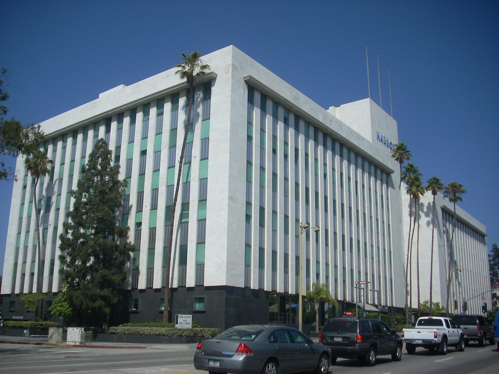
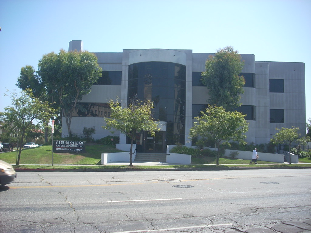
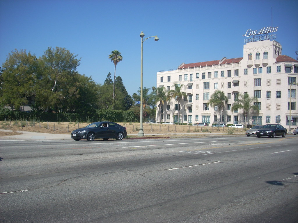
Harbor Building, Wilshire Boulevard and Crenshaw Boulevard
The Harbor Building is one of the landmarks that can be seen from a future subway station at Wilshire and Crenshaw boulevards.
Metro, understandably, is seeing more and more support for a Wilshire Boulevard subway throughout the line between its current terminus in Koreatown to the Westside — as well as a swell of unexpected support for an extension in West Hollywood.
During the last series of scoping meetings, Metro representatives said the board will likely vote on a preliminary line by Fall 2010. This gives the neighborhoods a year to formalize where they want stations and what construction methods should be used to complete the project.
One of the stations along the line is still kept as optional: Wilshire Boulevard and Crenshaw Boulevard. At first appearance, it might seem understandable why this intersection may be poorly suited for a subway station. The first is a sentiment of fierce opposition from the three neighborhoods that the station would serve: Park Mile, Windsor Square and Windsor Village. Second is what is seemingly poor prospects for ridership: a T-intersection where Crenshaw ends, “very low” density, zero retail activity and very limited commercial zoning. Third is zero potential for development of any kind, as the neighborhoods are protected by historic protection overlay zones and specific plans that mandate free parking.
They are challenges, but certainly not insurmountable. In the broad view, though, a station at Crenshaw Boulevard will play a vital role when the Purple Line is fully built. Conversely, the absence of a Crenshaw station will be noticeable, frustrating, and will close the window on a chance for the neighborhood to become a part of the subway. The neighborhood can rise up now and force Metro to remove the subway station, but there’s the very real possibility that in a few years, current residents will reverse themselves or the neighborhood profile changes and residents would be more favorable to a subway station. It happened before … namely along everywhere else on Wilshire.
I think that a Wilshire/Crenshaw station would be appropriate, it would stimulate a respectable level of ridership, and still be respectful of the historic character of the neighborhood.
More than meets the eye
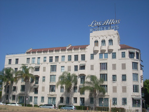
Los Altos Apartments Courtyard of Los Altos Apartments
Los Altos Apartments had seen its share of luxury in the early 20th century but went to seed during the last half. Now it is back again to recapture its splendor. The photo on the right is the courtyard seen from Wilshire Boulevard.
The neighborhoods around Wilshire/Crenshaw are multilayered — in more ways than one. The historic preservation zones attempts to impose a density limit and preserve the oldest and more palatial properties. However, the neighborhoods are hardly by the book. Mid-century development allowed a significant amount of density to trickle in. Some of the larger homes were divided up into duplexes, triplexes and quadriplexes, and a lot of homes during that time were knocked down for smaller apartment buildings and condos of 5-15 units. These are all mixed in the residential areas south of Wilshire.
Crenshaw Boulevard is an exception. Crenshaw is virtually all multiunit apartment buildings and condos of 2-4 stories between Wilshire and Olympic boulevards. It also has the connecting bus service of lines 210 and 710, which both connect with the subway in Hollywood or Koreatown, respectively.
As for the rest of the neighborhood, take a virtual walking tour of the neighborhoods surrounding the future station via Google Maps. Oddly enough, Crenshaw Boulevard is the only street the Google car has not motion-captured, but the apartments can be seen from the bird’s-eye view. But move the little man around and you’ll see splendid old homes, multiunits from converted homes and apartment buildings often all neighbors.
Does the neighborhood seem like it’s not dense enough to support heavy rail? Admittedly, this would apply for Windsor Square north of Wilshire. Yet most of the ridership is bound to come from south of Wilshire, with a chance of ridership coming from a dense pocket near the northeast as well. The likely ridership would come from an area bounded by Wilton Place to the east and Lucerne Boulevard and Rossmore Avenue to the west. There’s a gated community, Fremont Place, just west of Lucerne.
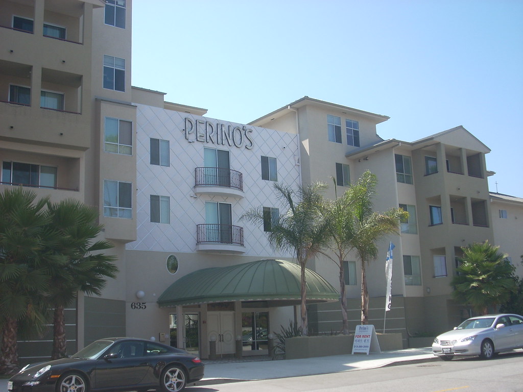
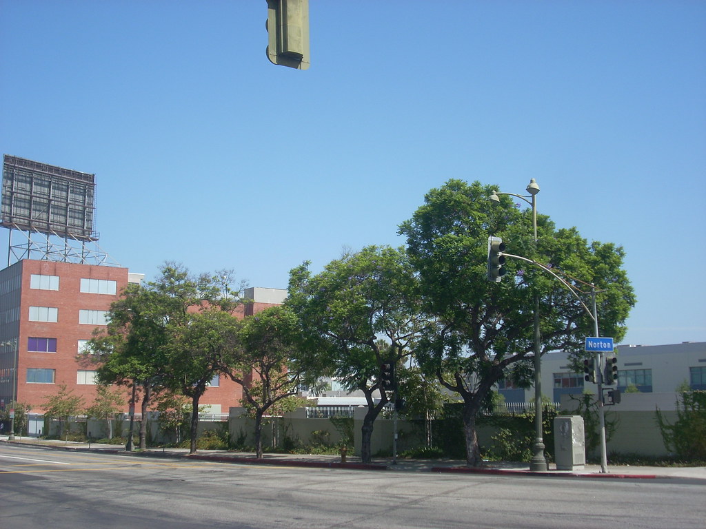
Perino's Apartments Perino's Apartments facing Wilshire Blvd.
Perino’s had once been one of L.A.’s most exclusive restaurants, but when it closed, the land sat empty for nearly 20 years until it had been redeveloped into these apartments. The front entrance on Norton incorporates the logo and the awning that used to be on the old restaurant. This apartment tests the restrictions of the Park Mile Specific Plan.
So what do the numbers say? Let’s consult the data from the Census Bureau. The maps use data that will be outdated by next year, but surely the 2010 Census will reveal that the neighborhood has become more populated. The snapshot is the census tracts near Wilshire and Crenshaw, with Wilton Place as the eastern boundary and Olympic Boulevard as the southern boundary. Wilton Place is about equidistant from Crenshaw and Western Avenue, and implicitly, residents east of Wilton are more likely to use the existing Wilshire/Western station.
Condo buildings at Wilshire Blvd. & Norton Av. Condos as seen from Wilshire Blvd. & Bronson Av.
These condo developments also sprang up in the past few years. The left photo shows the complexes extending on Norton Avenue from Wilshire Boulevard to Ingraham Street. These are across from a new elementary school. These had been built upon what was formerly the midrise building of MetLife. The right view shows the condos as seen on Wilshire at Bronson Avenue. This part of the building had replaced a dance and acting studio.
The Census maps allow for inspection by census tract, block group and block. The Wilshire/Crenshaw station encompasses three zip codes: 90005, 90010 and 90020. The table below provides links to each data set.
Census tract 90005 90010 90020
Block group 90005 90010 90020
Block 90005 90010 90020
When you examine census tract data and tabulate those to a map, you’ll see mostly pale squares under the default census tract category. There isn’t a single rectangle of the two darkest green shades. However, the key shows a tremendous variation of persons per square mile for each shade. The lowest density shade represents density of 4,233 to 12,342 persons per square mile. And the neighborhoods within a half-mile of Wilshire and Crenshaw tend to the higher end of that range. It rises somewhat east of Bronson, where the yellow boxes have 23,576 to 30,029 persons per square mile. And that divot of green south of 8th Street? That’s 35,000 and up.
The block group and block data reveal where the dense pockets of the area are, in finer detail.
So even if a subway station is put in a neighborhood frozen in time with no prospects of up-zoning, the community has the density to support a station with moderate passenger activity. Other census data indicate other factors that reveal a high degree of transit use in the neighborhood as of 2000, far stronger than the city and county as a whole. (Note: Data from 2005-2007 are available for the city and county, but not for the zip codes. Even with the newer figures, they don’t alter the outcomes of the community statistics.)
Factors, in percentages 90005 90010 90020 L.A. City L.A. County
Transit as a share of work trips 34.2 11.4 21.0 10.2 6.6
Walking as a share of work trips 4.9 5.6 4.1 3.6 2.9
Renter occupied units 92.9 75.1 91.3 61.4 52.1
Individuals below poverty level 34.6 16.4 28.5 22.1 17.9
Households with access to 0 or 1 vehicles 79 64.9 76.1 56.8 49.6
The neighborhoods have access to a few very frequent bus lines with Rapid and/or limited-stop service on all but one line. Here is the number of buses in each direction per hour for midday service (numbers have been rounded up to the next integer):
Weekdays Saturdays Sundays
16/316 8 8 8
20, 720 up to 21 up to 15 up to 14
28, 728 8 7 6
209 1 0 0
210, 710 7 7 5
The mansion dwellers northwest of Wilshire/Crenshaw may not have much use for a subway, but the supply of rentals and condos south of Wilshire are attractive neighborhoods for professional downtown or Westside workers who would want someplace quiet and architecturally stunning to live in and take the train to the job while using the car on weekends.
It’s bound to be a large market, and one that the subway can fulfill without having to turn every square inch of Windsor Village into condos. And these statistics are from what the area around the station looked like close to 10 years ago!
What Metro and the residents near the proposed station should expect, and plan for, is something similar to a suburban BART station sans parking. BART is legendary for inspiring anti-development movements in the Bay Area, as residents militate against moving density anywhere from existing levels. The rallying cry is almost always to prevent the San Francisco-bound train to prevent turning San Mateo or Contra Costa County into another San Francisco.
That’s fine, but the more residents fight density, the more housing prices rise. As prices rise — particularly among the rentals and condos — the more people will need to take on roommates or house guests to pay the lease or mortgage. So density finds a way to creep in. This is what is likely happening now in the neighborhood, explaining the census numbers.
So what else is there?
Three office buildings within a block of the subway portal:
4311 Wilshire Boulevard
4311 Wilshire Boulevard, between Windsor Street and Plymouth Boulevard
4221 Wilshire Blvd.
4221 Wilshire Boulevard, between Lorraine Boulevard and Windsor Street
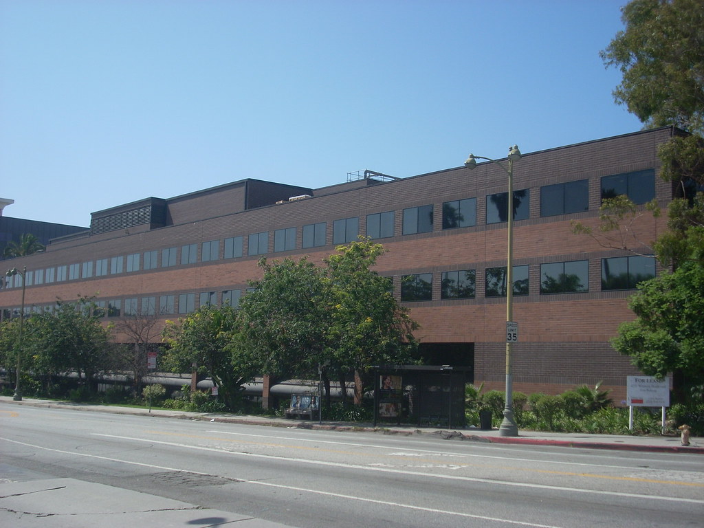
Office Building, Wilshire Blvd. and Bronson Av.
Wilshire Boulevard between Crenshaw Boulevard and Bronson Avenue
Wilshire/Crenshaw will pose a challenge as its ridership base would be from riders of the three connecting buses and nearby residents within walking distance — presumably all from south of Wilshire. Metro will also have nothing better than a station mouth, as the specific plan for the station neighborhood is geared to getting nothing built. Is this station in the middle of nowhere? No.
The Wilshire linear office corridor continues in Park Mile. These are some of the office buildings within a quarter mile walk of Wilshire and Crenshaw. The noticeable difference here is the deadness of activity. Unlike complexes in the adjacent Wilshire Center and Miracle Mile, there is zero ground floor retail activity. The only retail business between Wilton Place and Highland Avenue is a Chase bank branch at Plymouth Boulevard and across the street, the Dunes Motor Lodge.
These low-and-mid-rise complexes are a blessing in disguise. While city codes mandate free parking and place strict caps on density here, these buildings are easily adaptable to pedestrianism. Wilshire Boulevard had always been planned as a monument to the car, yet fortuitously the architectural design still insisted that buildings touch the street and that parking must be hidden underground or in the back. While Wilshire Boulevard may be dead, at least there is no moat of parking separating the entrances from the sidewalk.
The Park Mile land use plan has helped paint this stretch of Wilshire Boulevard into a corner. At first glance, the specific plan is inherently anti-transit. However, time and traffic have chipped away at Park Mile becoming an attractive auto commuting destination. Wilshire Boulevard is far from any freeways, and any access to them is limited and severely congested. Interstate 10 is two miles away, and US 101 is three miles away. When a worker arrives or leaves during rush hour, those 2-3 miles can feel like another work shift.
Then, of course, there’s the third rush hour. Since there are no pedestrians in Park Mile, there are no retail businesses. What do the workers in this area do? They drive to lunch in Wilshire Center or the Miracle Mile, where there are plenty of places to eat.
It’s really sad to go on about the troubles plaguing this stretch of Wilshire. Yet this is not a result of bad planning. Former planner and land use blogger Mitch Glaser liked to say that this failure was a result of following regulations to the letter; in other words, good planning caused this mess.
The more this stretch of Wilshire shows its myriad flaws, the more it seems a Crenshaw station would be a bad idea. Look, this piece is already 1,500 words long and the high concept is right in the title. The commercial corridor solidifies the case for the station, because a subway would set right all the problems caused by “good planning.”
For one, the subway parallels the 10 and 101, the two closest freeways that workers would drive. This would at least give these workers an alternative to the car, or a less stressful drive at the least. It also solves the third rush hour problem. Workers could take the Purple Line to Wilshire Center or the Miracle Mile for their lunch breaks.
Good for the mind and soul
Wilshire Park Elementary and office building
Wilshire Park Elementary at the southeast corner of Wilshire Boulevard and Norton Avenue had replaced a mid-rise tower that was used and later abandoned by MetLife. Next to it is a 4-story office building. At the end of the block at Wilton Place is a Social Security office.
Besides the “hostile” residences and funereal Wilshire Boulevard office buildings that would make a Wilshire/Crenshaw station more of a benefit than a burden, what else can help boost ridership? Try schools and churches.
There are two elementary schools within walking distance: Wilshire Park, just a block away from a subway portal; and Wilton Place, about five blocks from the station. There are also faith-based schools tied to the major churches in the area.
One, of course, has been the site of most of the subway scoping meetings: Wilshire United Methodist Church. There are also two Catholic churches within a half-mile walk: St. Gregory Nazianzen, at Norton Avenue and 9th Street; and St. Brendan, at Wilton Place and 3rd Street.
These churches wouldn’t just provide a slight ridership bump during Sunday services; these establishments also provide schools, child care and host social and community functions on the other six days as well. These churches even have served as polling places, which despite the implications of crossing church and state is quite routine for the Wilshire neighborhoods.
One more institution of note is the Ebell of Los Angeles, which would be three blocks away on Lucerne Boulevard. This long-standing women’s organization hosts events and runs a performing arts theater.
Where to put it
Three leading candidates in a beauty pageant of ugliness:
Wilshire/Crenshaw station site 1
Site 1: Wilshire Boulevard and Crenshaw Boulevard, southwest corner, stretching from Crenshaw to Lorraine Boulevard
Other Wilshire/Crenshaw parking lot
Site 2: Another Wilshire/Crenshaw parking lot, a smaller parcel on the southeast corner
Empty lot, Wilshire Blvd. between Irving Dr. and Bronson Av.
Site 3: An empty lot northeast of Crenshaw on Wilshire Boulevard between Irving Drive and Bronson Avenue
The Wilshire subway has been a project decades in the making. Metro’s predecessor, the Southern California Rapid Transit District, had already begun acquiring properties around Wilshire and Crenshaw in the 1970s. And it looks now just as it had then. Dead then, dead now.
At least, though, land has been banked for a subway station. There are three sites at the corner that allow for a quick and easy subway portal. That is also all that would be needed. That’s certainly all that would be allowed, if the community doesn’t use legal or extra-legal methods to kill a station.
None of these stations, though, would be suitable for a park & ride or an off-street bus layover zone. The NIMBYism speaks for itself, but aside from that, there are practical problems to each of these locations. The traffic flow is lousy in the area, even for the big lot. Buses certainly cannot navigate in and out of an off-street lot, and Wilshire/Western is a much stronger anchor terminal. Granted that any change in land use will require a flood of parking, all Metro would give this neighborhood is a subway portal and empty concrete. If space must be wasted, the two smaller parcels would be less wasteful.
Next stop, Wilshire/Crenshaw station
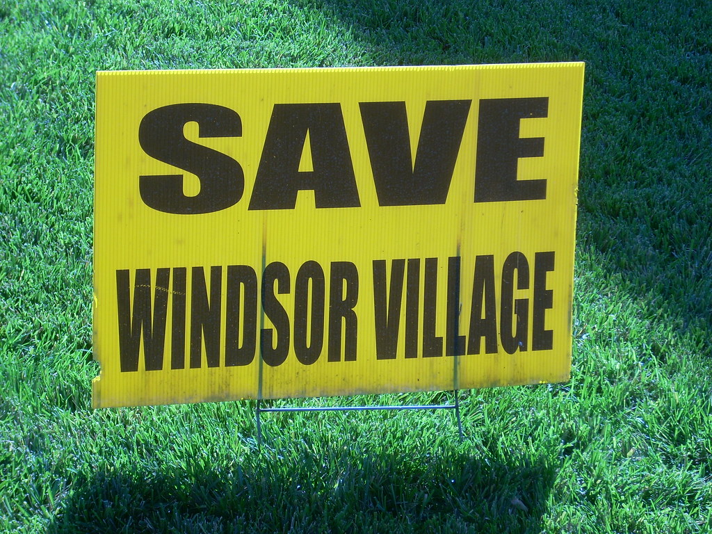
Save Windsor Village lawn sign
In this recession, few people are not willing to spend it — so don’t fret much.
I hope that this post opens a few eyes and minds. I am certainly mindful of the pitfalls of a Crenshaw station. So is Metro. There’s no indication that the community has warmed up to a subway station in their neighborhood, although this time they aren’t united in opposing a subway per se. We also have to go in knowing that there is no way the subway will turn Park Mile or the Windsors into another Hollywood & Highland.
Remember that the neighborhood wanted Wilshire to look the way it does. We cannot shame them into having Wilshire Center and Miracle Mile meet halfway. The best we can hope for is to get the portal at Crenshaw and leave the rest up to chance.
Yet in another way, it’s the kind of neighborhood many Angelenos and especially transit riders would appreciate. It has a non-urban urbanism. It’s dense living that doesn’t feel dense. It’s rich in history and one of the most pleasant places to take a stroll. It certainly has a beautiful collection of buildings. In this way, it’s sort of nice that time managed to stand still in these neighborhoods.
This is the kind of place the Purple Line needs. It’s a transit-oriented development that predated transit but doesn’t have to be changed for it to accommodate subway riders. It also shows that density does not have to overwhelm its residents.
And while there is very few retail within walking distance of the neighborhoods, the subway puts urban life within easy reach of where it already exists. A supermarket is one stop away, either at Western or at La Brea Avenue with a three block walk. And think of what is within 15 minutes or less of Wilshire and Crenshaw: the Miracle Mile, Wilshire Center, downtown L.A., Hollywood. If it’s not in the heart of it all, being pretty damn close to it has its own pluses.
I can understand all those yellow “Save Windsor Village” signs on properties — even, ironically, in front of apartment and condo complexes! Los Angeles is densifying, and that creates pressures to turn small estate homes and duplexes into McMansions or stucco-box condos. It’s one thing to preserve the character of historic properties.
It’s another thing when preserving history morphs into a siege mentality that has become the hallmark of the community groups. Density is not some evil conspiracy by developers to run people out of their happy homes. It’s a condition caused by circumstances that the community groups themselves had a big hand in creating. A million-dollar home isn’t just a Windsor Square mansion. It’s also the modest shoebox 3-bed, 2-bath, 1-car garage home between Harold Henry Park and Los Angeles High School. It also has historic character, so it can’t be knocked down or modified without a battery of nosy community activists and water-cooler dictators of the city and county bureaucracies.
So about the only activity left for a homeowner who pays good money to live in the neighborhood is mingle with the fellow landed gentry and just develop a monomaniacal obsession to maintain property values at all costs. So if anyone desires to do anything, err on the side of fear, uncertainty and doubt (FUD) and just fight. It has happened so much — especially north of Wilshire — that the fights don’t represent an end other than the fights themselves.
The Wilshire/Crenshaw station is likely to shape up to be one of those fights. And it’s one I hope the community doesn’t win. We’ve been through an arduous one with the Expo Line running through a sliver of Cheviot Hills, and it is still amazing that the better alternative prevailed. This time, the usual suspects are wealthier, have a better fight record and the stakes much greater.
Yes, Crenshaw is only about a half-mile from Western Avenue, but no station at Crenshaw would call much greater attention to the shortfalls of Metro Rail. Running nonstop between Western and La Brea is more than 2 miles, unacceptably long for a quintessentially urban subway system. Also, the subway system should serve the neighborhood because time can only be frustrated but not frozen.
Who’s to say what the outlook of residents will be 10 years after the subway runs? The houses are the same but the people are different. The area has become a lot more diverse, if not by income but certainly by demographics. The area has also become dense, mainly as a consequence of the high housing prices that place upward pressure on density. It didn’t happen with the dwellings, but the dwellers out of economic necessity.
If so much can still change when even everything manages to look the same, a Wilshire/Crenshaw station is well … just another day in the neighborhood.


No comments:
Post a Comment